Introduction to Geospatial Modelling -Geometric modelling in Geospatial Science
|
|
|
- Elsa Hakala
- 8 vuotta sitten
- Katselukertoja:
Transkriptio
1 Introduction to Geospatial Modelling -Geometric modelling in Geospatial Science Kirsi Virrantaus Aalto University School of Engineering Department of Built Environment
2 Content of the lecture Geometric Models in Geospatial Science Example on elevation model Appendix 2
3 Luennon sisältö Geometriset mallit Geoinformaatiotieteessä Esimerkki korkeusmallista Liite 3
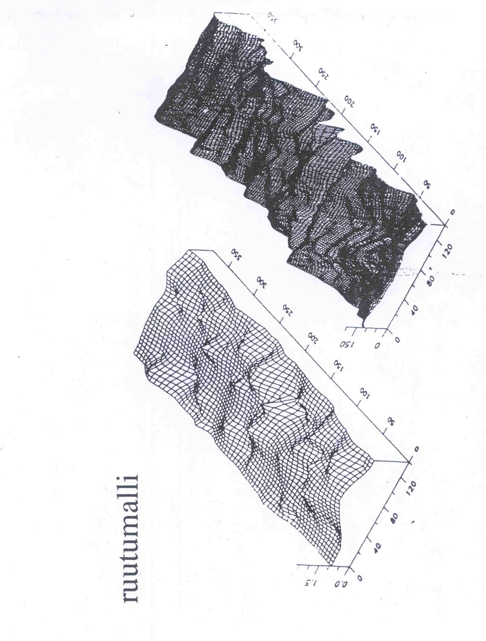
4 3. Models in Geospatial science? In Geoinformatics (Geospatial science) models are traditionally 2d and 2,5 d, but 3d and 4d are developing the surface of the Earth is one typical case for 3d or 2,5d geometric modeling Elevation model can be constructed and used in various ways 1. Contour model: in order to make a map the contours are created (as list of points) and they are visualized for example by applying splines in order to get a smoothed presentation 2. Surface model can be created by using a mathematical function has been fitted to the measured empirical data as well as possible; this model is not accurate but in some cases useful for analysis purposes 3. Grid model is a matrix presentation made by interpolation 3. TIN-model is a mesh of irregular triangles constructed by using the measured points as nodes; points keep their positional accuracy 4
5 Mallit geoinformaatiotieteessä Perinteisesti 2d ja 2,5d; mutta 3d- ja 4d-mallit kehittyvät Korkeusmalli Korkeuskäyrämalli; mitatuista pisteistä interpoloidaan käyrät, käyrät pehmennetään esimerkiksi splinillä Pintamalli; mitauuihin pisteisiin voidaan yrittää sovittaa matemaattinen funktio, ei tosin säilytä pisteiden tarkkuutta, mutta sopii joskus esimerkiksi analyysitehtävään Grid/ruutumalli; säännöllinen ruutumalli, joka luodaan tunnetuista pisteistä interpoloimalla TIN-malli; epäsäännöllinen kolmioverkkomalli, jossa tarkat pisteet säilyvät 5
6
")
7 Aronoff, 1991)
8 (Burrough&McDonnell, 1998)
9 Kolmioiden muodostuminen Viereiset kolmiot Koordinaatit (Aronoff, 1991)
10 Appendix Liite Spatial models Sijaintitietomallit
11 Spatial data, temporal data The elementary spatial characteristic, that separates spatial data from all other data types, is: location (x,y,z), (lat, long) Each event or phenomenon on the Earth can be somehow defined by location in space Analogically, each event of phenomenon can get temporal characteristics
12 Sijaintitieto ja aikatieto Perustavaa laatua oleva ominaisuus, joka erottaa sijaintitiedon kaikesta muusta tiedosta on: sijainti (x,y,z), (lat, long) Kaikki tapahtuvat/kohteet ja ilmiöt Maan vaikutuspiirissä voidaan tavalla tai toisella määrittää niiden sijainnin osalta Sama koskee aikadimensiota, eli kaikki tapahtumat voidaan sitoa jollain tavoin aikaan
13 Spatial phenomena can be described/modeled as objects or fields For computational purposes spatial phenomena must be modeled so that their formal (numerical/mathematical) expression is possible Two main approaches for modeling exist: Objects: the phenomenon is discretizised and modeled as discrete Points (control ponts, center points of buildings, accidents ) Lines (roads, streets, rivers ) Polygons (buildings, parcels, countries, lakes ) Fields: the phenomenon is taken as a continuous (2d, 3d or 4d) function of space and time Scalar fields showing the value of the attribute (elevation model, soil map ) Vector fields showing the attribute value/magnitude and direction (slope map)
14 Spatiaalisia ilmiöitä kuvataan kohteina tai jatkumoina Tietokonekäsittelyä varten spatiaalisia ilmiöitä on mallinnettava siten, että ne voidaan kuvata formaalisti (numeerisesti/matemaattisesti) Kaksi lähestymistapaa mallinnukseen: Kohteet: ilmiö diskretisoidaan ja mallinnetaan yksittäisinä Pisteinä Viivoina Alueina/polygoneina Kentät/jatkumot/kontinuumit: ilmiö mallinnetaan jatkuvana ajan ja paikan (2d, 3d, 4d) funktiona Skalaarikentät, ilmaisevat ominaisuuden arvon (korkeusmalli, maaperäkartta ) Vektorikentät, ilmaisevat sekä omaisuuden arvon/suuruuden, että suunnan (rinnekartta )
15 Pistemäiset kohteet voidaan muuntaa pintamaiseksi esitykseksi laskemalla pisteiden määrä annetun gridin ruuduissa ja sitten esittämällä määrät värillä tai harmaasävyllä Point objects can be transformed into field model by counting the sum of points in each cell of the given grid and then by representing the sums in colours or shades
16 Objects object data models are used for data collection from the field by point measurements for map digitizing purposes for databases and conceptual models points, lines, polygons, networks easy to link to relational data bases including attribute data in object model spatial data represent geographic reality in the form of static geometric objects associated attributes relations between objects
17 Kohteet Kohteista koostuva tietomalli on luonteva kun Kerätään tietoa maastosta mittaamalla kohteita Digitoidaan karttoja Tallennetaan tietoa tietokantaan ja käytetään käsitemalleja Pisteet, viivat, polygonit, verkot Kohteisiin on luontevaa yhdistää ominaisuustietoa ja kohteina mallinnettu sijaintitietokanta on yksinkertaista yhdistää ominaisuustietokantaan Kohdetyyppinen sijaintitietomalli perustuu Staattisiin geometrisiin kohteisiin Kohteiden ominaisuuksiin Kohteiden välisiin relaatioihin
18 Points, pisteet Lines, viivat Areas/polygons, alueet/polygonit

19 Point = accident (Spatenkova, 2009)

20 Roads - Tiet ZhangZhe, 2010
21 Fields many geographical phenomena exist everywhere elevation not just contours soil types changing from one type to another in a transition area, not discretely temperature, vegetation continuous or categorized values fields can model easily continuously varying, multivariate and dynamic phenomena
22 Kentät Jotkut maantieteelliset ilmiöt sijaitsevat kaikkialla, ovat jatkuvia ilmiöitä; niitä on vaikeaa mallintaa yksittäisinä kohteina Korkeustieto ei vain korkeuskäyrät Maaperä muuttuu vaihettumisalueiden kautta toisikseen Lämpötila, kasvillisuus Jatkuvia tai luokiteltuja muuttujia Kentät kuvaavat luontevasti Jatkuvasti muuttuvia, monimuuttujaisia ja dynaamisia ilmiöitä

23 Pistemäiset kohteet voidaan muuntaa pintamaiseksi esitykseksi laskemalla pisteiden määrä annetun gridin ruuduissa ja sitten esittämällä määrät värillä tai harmaasävyllä Point objects can be transformed into field model by counting the sum of points in each cell of the given grid and then by representing the sums in colours or shades
")
24 Accident points presented as a surface (Krisp,2006)
25 Soil map is a typical continuous phenomenon (Sunila,2009))
")
26 (Horttanainen & Virrantaus)
27 Notations for objects and fields notation for the objects tuple (=a liist with finite amount of elements) (x,g); x,y,x refers to location (X,Y), (X,Y,Z), (X,Y,Z,T); T = temporal dimension G stands for attributes notation for the fields function Z(x) ; x refers to location gets values in all locations; the values are created on the basis of the support of the function
28 Notaatiot (merkintätavat) kohteille ja kentille notaatio objekteille monikko (=lista, jossa äärellinen määrä alkioita) (x,g); x,y,z viittaa sijaintiin, voi olla (X,Y), (X,Y,Z), (X,Y,Z,T); T = temporaalinen dimensio G tarkoittaa ominaisuuksia notaatio kentille funktio Z(x) ; x viittaa sijaintiin saa arvon kaikissa sijainneisssa; funktion arvot määräytyvät sijainnin (kantajan) arvojen perusteella
29 Example of field type data: elevation. Contours represent the scalar field (can be also presented as a grid type elevation model. Arrows show the vector field: the slopes. (O Sullivan & Unwin, 2003, p.237) Esimerkki kenttädatasta: korkeusmalli. Korkeuskäyrät kuvaavat skalaarikenttää, joka voidaan esittää myös gridirakenteena. Nuolet kuvaavat vektorikenttää: kaltevuus.
30 Vektorikentän Visualisointi: kaltevuus ja Viettosuunta. Visualization of a vecor field: slope and aspect.
31 Object models, more in object model, spatial data is presented as points, lines and areas various forms of object types point (0-dimensional): point, node, vertex, 0-cell line (1-dimensional): line segment, string, arc, link, directed link, chair, ring, 1-cell area (2-dimensional): interior area, polygon (simple, complex), face, 2-cell, pixel, grid cell entity: discrete objects of same type are often called as entities class or layer: a collection of entities feature: points, lines, areas are sometimes called as features; also used for entities
32 Objektimalli Objektimallina spatiaalinen kohde kuvataan Pisteenä, viivana, alueena Useita nimityksiä piste kärki, solmu (verkon osana) viiva kaari, sivu, linkki (verkon osana) polygoni alue, pinta entity = kohde; samanlaisista kohteista kohdeluokka; myös layer, taso feature= osa, yksityiskohta; pisteistä, viivoista ja alueista; myös kohteista
33 Standardization of geometric concepts standardized definitions of elementary parts feature = an abstraction of a real world phenomenon; it is a geographic feature if it is associated with a location relative to the Earth Point, Curve, Surface, GeometryCollection; subclasses
34 Geometristen käsitteiden standardointi standardoidut alkeisgeometrioiden määrittelyt feature = an abstraction of a real world phenomenon; it is a geographic feature if it is associated with a location relative to the Earth Piste, Käyrä, Pinta, GeometriaRyhmä; alaluokat
35 Fields, more the concept of field has been taken to GIS from mathematics/physics via the notion of force fields (gravitational, magnetic) a field can be mathematically modeled as a function of spatial and temporal location scalar fields have only a scalar (single) value vector fields have multiple values (like magnitude and direction)
36 Kentät Kentän käsite matematiikasta/fysiikasta tuttu Painovoimakentät, magneettiset kentät Kenttä kuvataan matemaattisesti Spatiotemporaalisen sijainnin funktiona Skalaarikentällä vain skalaariarvo (ominaisuus) Vektorikentillä määrä ja suunta
37 Field models are described/modeled as irregular points, regular points, contours, polygons, grids, TIN s with continuous or categorical values continuous values are measured on continuous scales with interval or ratio properties categorical values are measured on discrete scales with nominal or ordinal properties
38 Kenttämallia kuvataan monin tavoin epäsäännölliset pisteet, säännölliset pisteet, korkeuskäyrät, polygonit, gridi, TIN jatkuvat tai luokitellut arvot jatkuvia arvoja mitataan jatkuvilla skaaloilla, välimatka- tai suhdeasteikoilla Välimatka: vakiosuuruinen mittayksikkö, 0-piste sopimus Suhde: luonnollinen 0-piste on luokiteltuja arvoja mitataan diskreeteillä skaaloilla nominaali- ja järjestysasteikoilla Nominali: vain laatu/luokittelu Järjestys: luokkien välinen järjestys tunnetaan
, CAD and GIS integration, Chapters 1 & 2, pp. 1 50. Wise, S., GIS Basics, Chapter 9, pp.")
39 Literature related to this lecture Cottrell., A., Hughes,T.J.R., Bazilevs,Y., Isogeometric analysis, Towards integration of CAD and FEA, Chapter 1, pp Mortenson, M., Geometric Modeling, Chapter 1, pp. 1 6 Karimi,H.A., Akinci,B., (eds), CAD and GIS integration, Chapters 1 & 2, pp Wise, S., GIS Basics, Chapter 9, pp Kuvien lähteitä/references from: De Berg, M., van Kreveld,M.,Overmars,M.,Schwarzkopf, Computational Geometry, 1997 Longley, P., Goodchild,M., Maguire,D., Rhind,D., Geographic Information Systems and Science, 2005 (this book is available as an e-book) Cormen,T.H., Leiserson, C.,A.,Rivest, R.L.,Stein, C.,.Introduction to Algorithms, Laurini,R., Thompson,D., Fundamentals of Spatial Information Systems. Burrough,P., MacDonnell,R.,Principles of Geographic information systems, Aronoff,S., Geographic Information Systems, A Management Perspective, 1991) 39
Geoinformation in Environmental Modelling
 Geoinformation in Environmental Modelling Modelling: from concepts to data models ENY-C2005 Paula Ahonen-Rainio 13.1.2015 Topics today Recap: Two approaches in spatial modelling: discrete objects and fields
Capacity Utilization
 Capacity Utilization Tim Schöneberg 28th November Agenda Introduction Fixed and variable input ressources Technical capacity utilization Price based capacity utilization measure Long run and short run
Introduction to Geometric Modelling -CAD, BIM and GIS for building design and city models
 Introduction to Geometric Modelling -CAD, BIM and GIS for building design and city models Kirsi Virrantaus Aalto University School of Engineering Department of Built Environment 22.2.2016 Content of the
Introduction to Geometric Modelling -Different approaches and their basic concepts
 Introduction to Geometric Modelling -Different approaches and their basic concepts Kirsi Virrantaus Aalto University School of Engineering Department of Built Environment 22.2.2016 Content of the lecture
Alternative DEA Models
 Mat-2.4142 Alternative DEA Models 19.9.2007 Table of Contents Banker-Charnes-Cooper Model Additive Model Example Data Home assignment BCC Model (Banker-Charnes-Cooper) production frontiers spanned by convex
Other approaches to restrict multipliers
 Other approaches to restrict multipliers Heikki Tikanmäki Optimointiopin seminaari 10.10.2007 Contents Short revision (6.2) Another Assurance Region Model (6.3) Cone-Ratio Method (6.4) An Application of
The CCR Model and Production Correspondence
 The CCR Model and Production Correspondence Tim Schöneberg The 19th of September Agenda Introduction Definitions Production Possiblity Set CCR Model and the Dual Problem Input excesses and output shortfalls
Efficiency change over time
 Efficiency change over time Heikki Tikanmäki Optimointiopin seminaari 14.11.2007 Contents Introduction (11.1) Window analysis (11.2) Example, application, analysis Malmquist index (11.3) Dealing with panel
On instrument costs in decentralized macroeconomic decision making (Helsingin Kauppakorkeakoulun julkaisuja ; D-31)
") On instrument costs in decentralized macroeconomic decision making (Helsingin Kauppakorkeakoulun julkaisuja ; D-31) Juha Kahkonen Click here if your download doesn"t start automatically On instrument costs
On instrument costs in decentralized macroeconomic decision making (Helsingin Kauppakorkeakoulun julkaisuja ; D-31) Juha Kahkonen Click here if your download doesn"t start automatically On instrument costs
7.4 Variability management
 7.4 Variability management time... space software product-line should support variability in space (different products) support variability in time (maintenance, evolution) 1 Product variation Product
16. Allocation Models
 16. Allocation Models Juha Saloheimo 17.1.27 S steemianalsin Optimointiopin seminaari - Sks 27 Content Introduction Overall Efficienc with common prices and costs Cost Efficienc S steemianalsin Revenue
Use of spatial data in the new production environment and in a data warehouse
 Use of spatial data in the new production environment and in a data warehouse Nordic Forum for Geostatistics 2007 Session 3, GI infrastructure and use of spatial database Statistics Finland, Population
C++11 seminaari, kevät Johannes Koskinen
 C++11 seminaari, kevät 2012 Johannes Koskinen Sisältö Mikä onkaan ongelma? Standardidraftin luku 29: Atomiset tyypit Muistimalli Rinnakkaisuus On multicore systems, when a thread writes a value to memory,
Introduction to Geometric Modelling - CAD and FEM for solid modeling and analysis
 Introduction to Geometric Modelling - CAD and FEM for solid modeling and analysis Kirsi Virrantaus Aalto University School of Engineering Department of Built Environment 20.2.2016 Content of the lecture
OpenStreetMap-aineistojen haltuunotto GDAL:lla
 OpenStreetMap-aineistojen haltuunotto GDAL:lla Jukka Rahkonen, http://latuviitta.org Viimeksi muutettu 22. heinäkuuta 2012 GDAL/OGR tukee OpenStreetMap-aineistojen lukemista GDAL-versiosta 2.0 alkaen.
National Building Code of Finland, Part D1, Building Water Supply and Sewerage Systems, Regulations and guidelines 2007
 National Building Code of Finland, Part D1, Building Water Supply and Sewerage Systems, Regulations and guidelines 2007 Chapter 2.4 Jukka Räisä 1 WATER PIPES PLACEMENT 2.4.1 Regulation Water pipe and its
make and make and make ThinkMath 2017
 Adding quantities Lukumäärienup yhdistäminen. Laske yhteensä?. Countkuinka howmonta manypalloja ballson there are altogether. and ja make and make and ja make on and ja make ThinkMath 7 on ja on on Vaihdannaisuus
Information on preparing Presentation
 Information on preparing Presentation Seminar on big data management Lecturer: Spring 2017 20.1.2017 1 Agenda Hints and tips on giving a good presentation Watch two videos and discussion 22.1.2017 2 Goals
Valuation of Asian Quanto- Basket Options
 Valuation of Asian Quanto- Basket Options (Final Presentation) 21.11.2011 Thesis Instructor and Supervisor: Prof. Ahti Salo Työn saa tallentaa ja julkistaa Aalto-yliopiston avoimilla verkkosivuilla. Muilta
TM ETRS-TM35FIN-ETRS89 WTG
 SHADOW - Main Result Assumptions for shadow calculations Maximum distance for influence Calculate only when more than 20 % of sun is covered by the blade Please look in WTG table WindPRO version 2.8.579
The Viking Battle - Part Version: Finnish
 The Viking Battle - Part 1 015 Version: Finnish Tehtävä 1 Olkoon kokonaisluku, ja olkoon A n joukko A n = { n k k Z, 0 k < n}. Selvitä suurin kokonaisluku M n, jota ei voi kirjoittaa yhden tai useamman
1.3 Lohkorakenne muodostetaan käyttämällä a) puolipistettä b) aaltosulkeita c) BEGIN ja END lausekkeita d) sisennystä
 puolipistettä b) aaltosulkeita c) BEGIN ja END lausekkeita d) sisennystä") OULUN YLIOPISTO Tietojenkäsittelytieteiden laitos Johdatus ohjelmointiin 811122P (5 op.) 12.12.2005 Ohjelmointikieli on Java. Tentissä saa olla materiaali mukana. Tenttitulokset julkaistaan aikaisintaan
OULUN YLIOPISTO Tietojenkäsittelytieteiden laitos Johdatus ohjelmointiin 811122P (5 op.) 12.12.2005 Ohjelmointikieli on Java. Tentissä saa olla materiaali mukana. Tenttitulokset julkaistaan aikaisintaan
Tietorakenteet ja algoritmit
 Tietorakenteet ja algoritmit Taulukon edut Taulukon haitat Taulukon haittojen välttäminen Dynaamisesti linkattu lista Linkatun listan solmun määrittelytavat Lineaarisen listan toteutus dynaamisesti linkattuna
On instrument costs in decentralized macroeconomic decision making (Helsingin Kauppakorkeakoulun julkaisuja ; D-31)
") On instrument costs in decentralized macroeconomic decision making (Helsingin Kauppakorkeakoulun julkaisuja ; D-31) Juha Kahkonen Click here if your download doesn"t start automatically On instrument costs
On instrument costs in decentralized macroeconomic decision making (Helsingin Kauppakorkeakoulun julkaisuja ; D-31) Juha Kahkonen Click here if your download doesn"t start automatically On instrument costs
( ( OX2 Perkkiö. Rakennuskanta. Varjostus. 9 x N131 x HH145
 OX2 9 x N131 x HH145 Rakennuskanta Asuinrakennus Lomarakennus Liike- tai julkinen rakennus Teollinen rakennus Kirkko tai kirkollinen rak. Muu rakennus Allas Varjostus 1 h/a 8 h/a 20 h/a 0 0,5 1 1,5 2 km
anna minun kertoa let me tell you
 anna minun kertoa let me tell you anna minun kertoa I OSA 1. Anna minun kertoa sinulle mitä oli. Tiedän että osaan. Kykenen siihen. Teen nyt niin. Minulla on oikeus. Sanani voivat olla puutteellisia mutta
Analysis of field data Introduction to Kriging. Kirsi Virrantaus GIS-E1060 Spatial Analytics
 Analysis of field data Introduction to Kriging Kirsi Virrantaus GIS-E1060 Spatial Analytics 8.11.2016 Kenttädatan analyysi Johdanto krigingiin Kirsi Virrantaus GIS-E1060 Spatial Analytics 8.11.2016 Contents
Results on the new polydrug use questions in the Finnish TDI data
 Results on the new polydrug use questions in the Finnish TDI data Multi-drug use, polydrug use and problematic polydrug use Martta Forsell, Finnish Focal Point 28/09/2015 Martta Forsell 1 28/09/2015 Esityksen
TM ETRS-TM35FIN-ETRS89 WTG
 SHADOW - Main Result Assumptions for shadow calculations Maximum distance for influence Calculate only when more than 20 % of sun is covered by the blade Please look in WTG table WindPRO version 2.8.579
Metsälamminkankaan tuulivoimapuiston osayleiskaava
 VAALAN KUNTA TUULISAIMAA OY Metsälamminkankaan tuulivoimapuiston osayleiskaava Liite 3. Varjostusmallinnus FCG SUUNNITTELU JA TEKNIIKKA OY 12.5.2015 P25370 SHADOW - Main Result Assumptions for shadow calculations
TM ETRS-TM35FIN-ETRS89 WTG
 SHADOW - Main Result Assumptions for shadow calculations Maximum distance for influence Calculate only when more than 20 % of sun is covered by the blade Please look in WTG table WindPRO version 2.8.579
KMTK lentoestetyöpaja - Osa 2
 KMTK lentoestetyöpaja - Osa 2 Veijo Pätynen 18.10.2016 Pasila YHTEISTYÖSSÄ: Ilmailun paikkatiedon hallintamalli Ilmailun paikkatiedon hallintamalli (v0.9 4.3.2016) 4.4 Maanmittauslaitoksen rooli ja vastuut...
Liikenneverkot-tietotuote
 Liikenneverkot-tietotuote Tietotuotteet kuntoon 27.10.2017 27.10.2017 Sisältö 1. Miten lähdettiin liikkeelle 2. Välineet ja prosessit 3. Haasteet 4. Validointi 5. Hyödyntäminen 6. Lessons learned 27.10.2017
Paikkatiedon semanttinen mallinnus, integrointi ja julkaiseminen Case Suomalainen ajallinen paikkaontologia SAPO
 Paikkatiedon semanttinen mallinnus, integrointi ja julkaiseminen Case Suomalainen ajallinen paikkaontologia SAPO Tomi Kauppinen, Eero Hyvönen, Jari Väätäinen Semantic Computing Research Group (SeCo) http://www.seco.tkk.fi/
812336A C++ -kielen perusteet, 21.8.2010
 812336A C++ -kielen perusteet, 21.8.2010 1. Vastaa lyhyesti seuraaviin kysymyksiin (1p kaikista): a) Mitä tarkoittaa funktion ylikuormittaminen (overloading)? b) Mitä tarkoittaa jäsenfunktion ylimääritys
1.3Lohkorakenne muodostetaan käyttämällä a) puolipistettä b) aaltosulkeita c) BEGIN ja END lausekkeita d) sisennystä
 puolipistettä b) aaltosulkeita c) BEGIN ja END lausekkeita d) sisennystä") OULUN YLIOPISTO Tietojenkäsittelytieteiden laitos Johdatus ohjelmointiin 81122P (4 ov.) 30.5.2005 Ohjelmointikieli on Java. Tentissä saa olla materiaali mukana. Tenttitulokset julkaistaan aikaisintaan
OULUN YLIOPISTO Tietojenkäsittelytieteiden laitos Johdatus ohjelmointiin 81122P (4 ov.) 30.5.2005 Ohjelmointikieli on Java. Tentissä saa olla materiaali mukana. Tenttitulokset julkaistaan aikaisintaan
Tynnyrivaara, OX2 Tuulivoimahanke. ( Layout 9 x N131 x HH145. Rakennukset Asuinrakennus Lomarakennus 9 x N131 x HH145 Varjostus 1 h/a 8 h/a 20 h/a
 , Tuulivoimahanke Layout 9 x N131 x HH145 Rakennukset Asuinrakennus Lomarakennus 9 x N131 x HH145 Varjostus 1 h/a 8 h/a 20 h/a 0 0,5 1 1,5 km 2 SHADOW - Main Result Assumptions for shadow calculations
Geoinformation in Environmental Modelling
 Geoinformation in Environmental Modelling Spatial analysis: density surface spatial interpolation network analysis ENY-C2005 Paula Ahonen-Rainio 3.2.2016 Topics today From a set of points to a surface
Bounds on non-surjective cellular automata
 Bounds on non-surjective cellular automata Jarkko Kari Pascal Vanier Thomas Zeume University of Turku LIF Marseille Universität Hannover 27 august 2009 J. Kari, P. Vanier, T. Zeume (UTU) Bounds on non-surjective
Analysis of polygon maps. Kirsi Virrantaus GIS-E1060 Spatial Analytics
 Analysis of polygon maps Kirsi Virrantaus GIS-E1060 Spatial Analytics 1.11.2016 Polygonikarttojen analyysi Kirsi Virrantaus GIS-E1060 Spatial Analytics 1.11.2016 Contents of the lecture Polygons and polygon
Infrastruktuurin asemoituminen kansalliseen ja kansainväliseen kenttään Outi Ala-Honkola Tiedeasiantuntija
 Infrastruktuurin asemoituminen kansalliseen ja kansainväliseen kenttään Outi Ala-Honkola Tiedeasiantuntija 1 Asemoitumisen kuvaus Hakemukset parantuneet viime vuodesta, mutta paneeli toivoi edelleen asemoitumisen
1. Liikkuvat määreet
 1. Liikkuvat määreet Väitelauseen perussanajärjestys: SPOTPA (subj. + pred. + obj. + tapa + paikka + aika) Suora sanajärjestys = subjekti on ennen predikaattia tekijä tekeminen Alasääntö 1: Liikkuvat määreet
4x4cup Rastikuvien tulkinta
 4x4cup Rastikuvien tulkinta 4x4cup Control point picture guidelines Päivitetty kauden 2010 sääntöihin Updated for 2010 rules Säännöt rastikuvista Kilpailijoiden tulee kiinnittää erityistä huomiota siihen,
Gap-filling methods for CH 4 data
 Gap-filling methods for CH 4 data Sigrid Dengel University of Helsinki Outline - Ecosystems known for CH 4 emissions; - Why is gap-filling of CH 4 data not as easy and straight forward as CO 2 ; - Gap-filling
AYYE 9/ HOUSING POLICY
 AYYE 9/12 2.10.2012 HOUSING POLICY Mission for AYY Housing? What do we want to achieve by renting apartments? 1) How many apartments do we need? 2) What kind of apartments do we need? 3) To whom do we
TM ETRS-TM35FIN-ETRS89 WTG
 SHADOW - Main Result Assumptions for shadow calculations Maximum distance for influence Calculate only when more than 20 % of sun is covered by the blade Please look in WTG table WindPRO version 2.9.269
TM ETRS-TM35FIN-ETRS89 WTG
 SHADOW - Main Result Calculation: N117 x 9 x HH141 Assumptions for shadow calculations Maximum distance for influence Calculate only when more than 20 % of sun is covered by the blade Please look in WTG
,0 Yes ,0 120, ,8
 SHADOW - Main Result Calculation: Alue 2 ( x 9 x HH120) TuuliSaimaa kaavaluonnos Assumptions for shadow calculations Maximum distance for influence Calculate only when more than 20 % of sun is covered
Telecommunication Software
 Telecommunication Software Final exam 21.11.2006 COMPUTER ENGINEERING LABORATORY 521265A Vastaukset englanniksi tai suomeksi. / Answers in English or in Finnish. 1. (a) Määrittele sovellusviesti, PersonnelRecord,
WindPRO version joulu 2012 Printed/Page :42 / 1. SHADOW - Main Result
 SHADOW - Main Result Assumptions for shadow calculations Maximum distance for influence Calculate only when more than 20 % of sun is covered by the blade Please look in WTG table 13.6.2013 19:42 / 1 Minimum
Basic Flute Technique
 Herbert Lindholm Basic Flute Technique Peruskuviot huilulle op. 26 Helin & Sons, Helsinki Basic Flute Technique Foreword This book has the same goal as a teacher should have; to make himself unnecessary.
TM ETRS-TM35FIN-ETRS89 WTG
 VE1 SHADOW - Main Result Calculation: 8 x Nordex N131 x HH145m Assumptions for shadow calculations Maximum distance for influence Calculate only when more than 20 % of sun is covered by the blade Please
Returns to Scale II. S ysteemianalyysin. Laboratorio. Esitelmä 8 Timo Salminen. Teknillinen korkeakoulu
 Returns to Scale II Contents Most Productive Scale Size Further Considerations Relaxation of the Convexity Condition Useful Reminder Theorem 5.5 A DMU found to be efficient with a CCR model will also be
KONEISTUSKOKOONPANON TEKEMINEN NX10-YMPÄRISTÖSSÄ
 KONEISTUSKOKOONPANON TEKEMINEN NX10-YMPÄRISTÖSSÄ https://community.plm.automation.siemens.com/t5/tech-tips- Knowledge-Base-NX/How-to-simulate-any-G-code-file-in-NX- CAM/ta-p/3340 Koneistusympäristön määrittely
WindPRO version joulu 2012 Printed/Page :47 / 1. SHADOW - Main Result
 SHADOW - Main Result Assumptions for shadow calculations Maximum distance for influence Calculate only when more than 20 % of sun is covered by the blade Please look in WTG table WindPRO version 2.8.579
1. SIT. The handler and dog stop with the dog sitting at heel. When the dog is sitting, the handler cues the dog to heel forward.
 START START SIT 1. SIT. The handler and dog stop with the dog sitting at heel. When the dog is sitting, the handler cues the dog to heel forward. This is a static exercise. SIT STAND 2. SIT STAND. The
( ,5 1 1,5 2 km
 Tuulivoimala Rakennukset Asuinrakennus Liikerak. tai Julkinen rak. Lomarakennus Teollinen rakennus Kirkollinen rakennus Varjostus "real case" h/a 1 h/a 8 h/a 20 h/a 4 5 3 1 2 6 7 8 9 10 0 0,5 1 1,5 2 km
Insinööritieteen laskenta ja mallinnus Computation and Modeling in Engineering (CME) Introduction and motivation to the course and CME minor
 Introduction and motivation to the course and CME minor") Insinööritieteen laskenta ja mallinnus Computation and Modeling in Engineering (CME) Introduction and motivation to the course and CME minor Kirsi Virrantaus Aalto-yliopisto, Insinööritieteen korkeakoulu
Insinööritieteen laskenta ja mallinnus Computation and Modeling in Engineering (CME) Introduction and motivation to the course and CME minor Kirsi Virrantaus Aalto-yliopisto, Insinööritieteen korkeakoulu
Office 2013 ja SQL Server 2012 SP1 uudet BI toiminnallisuudet Marko Somppi/Invenco Oy
 t Office 2013 ja SQL Server 2012 SP1 uudet BI toiminnallisuudet Marko Somppi/Invenco Oy Agenda 1. Office Excel 2013 2. SharePoint 2013 3. SQL Server 2012 SP1 4. SharePoint 2013 BI-arkkitehtuuri 5. Kunta-analyysi
Uusi Ajatus Löytyy Luonnosta 4 (käsikirja) (Finnish Edition)
 (Finnish Edition)") Uusi Ajatus Löytyy Luonnosta 4 (käsikirja) (Finnish Edition) Esko Jalkanen Click here if your download doesn"t start automatically Uusi Ajatus Löytyy Luonnosta 4 (käsikirja) (Finnish Edition) Esko Jalkanen
Uusi Ajatus Löytyy Luonnosta 4 (käsikirja) (Finnish Edition) Esko Jalkanen Click here if your download doesn"t start automatically Uusi Ajatus Löytyy Luonnosta 4 (käsikirja) (Finnish Edition) Esko Jalkanen
Counting quantities 1-3
 Counting quantities 1-3 Lukumäärien 1 3 laskeminen 1. Rastita Tick (X) (X) the kummassa box that has laatikossa more on balls enemmän in it. palloja. X. Rastita Tick (X) (X) the kummassa box that has laatikossa
TM ETRS-TM35FIN-ETRS89 WTG
 SHADOW - Main Result Assumptions for shadow calculations Maximum distance for influence Calculate only when more than 20 % of sun is covered by the blade Please look in WTG table 22.12.2014 11:33 / 1 Minimum
Network to Get Work. Tehtäviä opiskelijoille Assignments for students. www.laurea.fi
 Network to Get Work Tehtäviä opiskelijoille Assignments for students www.laurea.fi Ohje henkilöstölle Instructions for Staff Seuraavassa on esitetty joukko tehtäviä, joista voit valita opiskelijaryhmällesi
Operatioanalyysi 2011, Harjoitus 2, viikko 38
 Operatioanalyysi 2011, Harjoitus 2, viikko 38 H2t1, Exercise 1.1. H2t2, Exercise 1.2. H2t3, Exercise 2.3. H2t4, Exercise 2.4. H2t5, Exercise 2.5. (Exercise 1.1.) 1 1.1. Model the following problem mathematically:
Making use of BIM in energy management
 BuildingEQ-Symposium in Berlin, October 1, 2009 Making use of BIM in energy management Tuomas Laine Olof Granlund Oy www.buildingeq.net Content BIM based tools for energy performance analysis and thermal
SIMULINK S-funktiot. SIMULINK S-funktiot
 S-funktio on ohjelmointikielellä (Matlab, C, Fortran) laadittu oma algoritmi tai dynaamisen järjestelmän kuvaus, jota voidaan käyttää Simulink-malleissa kuin mitä tahansa valmista lohkoa. S-funktion rakenne
TM ETRS-TM35FIN-ETRS89 WTG
 SHADOW - Main Result Assumptions for shadow calculations Maximum distance for influence Calculate only when more than 20 % of sun is covered by the blade Please look in WTG table 5.11.2013 16:44 / 1 Minimum
Characterization of clay using x-ray and neutron scattering at the University of Helsinki and ILL
 Characterization of clay using x-ray and neutron scattering at the University of Helsinki and ILL Ville Liljeström, Micha Matusewicz, Kari Pirkkalainen, Jussi-Petteri Suuronen and Ritva Serimaa 13.3.2012
Operatioanalyysi 2011, Harjoitus 3, viikko 39
 Operatioanalyysi 2011, Harjoitus 3, viikko 39 H3t1, Exercise 3.1. H3t2, Exercise 3.2. H3t3, Exercise 3.3. H3t4, Exercise 3.4. H3t5 (Exercise 3.1.) 1 3.1. Find the (a) standard form, (b) slack form of the
TM ETRS-TM35FIN-ETRS89 WTG
 SHADOW - Main Result Assumptions for shadow calculations Maximum distance for influence Calculate only when more than 20 % of sun is covered by the blade Please look in WTG table WindPRO version 2.8.579
TM ETRS-TM35FIN-ETRS89 WTG
 SHADOW - Main Result Assumptions for shadow calculations Maximum distance for influence Calculate only when more than 20 % of sun is covered by the blade Please look in WTG table WindPRO version 2.8.579
VBE2 Työpaketit Jiri Hietanen / TTY
 VBE2 Työpaketit Jiri Hietanen / TTY 1 WP2.1 Technology review and VBE platform 2 Tavoitteet In In charge: charge: Method: Method: Jiri Jiri Hietanen, Hietanen, TUT TUT Analysis Analysis of of existing
S Sähkön jakelu ja markkinat S Electricity Distribution and Markets
 S-18.3153 Sähkön jakelu ja markkinat S-18.3154 Electricity Distribution and Markets Voltage Sag 1) Kolmivaiheinen vastukseton oikosulku tapahtuu 20 kv lähdöllä etäisyydellä 1 km, 3 km, 5 km, 8 km, 10 km
TM ETRS-TM35FIN-ETRS89 WTG
 SHADOW - Main Result Assumptions for shadow calculations Maximum distance for influence Calculate only when more than 20 % of sun is covered by the blade Please look in WTG table WindPRO version 2.8.579
FinFamily PostgreSQL installation ( ) FinFamily PostgreSQL
 FinFamily PostgreSQL") FinFamily PostgreSQL 1 Sisällys / Contents FinFamily PostgreSQL... 1 1. Asenna PostgreSQL tietokanta / Install PostgreSQL database... 3 1.1. PostgreSQL tietokannasta / About the PostgreSQL database...
FinFamily PostgreSQL 1 Sisällys / Contents FinFamily PostgreSQL... 1 1. Asenna PostgreSQL tietokanta / Install PostgreSQL database... 3 1.1. PostgreSQL tietokannasta / About the PostgreSQL database...
On instrument costs in decentralized macroeconomic decision making (Helsingin Kauppakorkeakoulun julkaisuja ; D-31)
") On instrument costs in decentralized macroeconomic decision making (Helsingin Kauppakorkeakoulun julkaisuja ; D-31) Juha Kahkonen Click here if your download doesn"t start automatically On instrument costs
On instrument costs in decentralized macroeconomic decision making (Helsingin Kauppakorkeakoulun julkaisuja ; D-31) Juha Kahkonen Click here if your download doesn"t start automatically On instrument costs
Sisällysluettelo Table of contents
 Sisällysluettelo Table of contents OTC:n Moodlen käyttöohje suomeksi... 1 Kirjautuminen Moodleen... 2 Ensimmäinen kirjautuminen Moodleen... 2 Salasanan vaihto... 2 Oma käyttäjäprofiili... 3 Työskentely
x = y x i = y i i = 1, 2; x + y = (x 1 + y 1, x 2 + y 2 ); x y = (x 1 y 1, x 2 + y 2 );
; x y = (x 1 y 1, x 2 + y 2 );") LINEAARIALGEBRA Harjoituksia/Exercises 2017 1. Olkoon n Z +. Osoita, että (R n, +, ) on lineaariavaruus, kun vektoreiden x = (x 1,..., x n ), y = (y 1,..., y n ) identtisyys, yhteenlasku ja reaaliluvulla
LINEAARIALGEBRA Harjoituksia/Exercises 2017 1. Olkoon n Z +. Osoita, että (R n, +, ) on lineaariavaruus, kun vektoreiden x = (x 1,..., x n ), y = (y 1,..., y n ) identtisyys, yhteenlasku ja reaaliluvulla
toukokuu 2011: Lukion kokeiden kehittämistyöryhmien suunnittelukokous
 Tuula Sutela toukokuu 2011: Lukion kokeiden kehittämistyöryhmien suunnittelukokous äidinkieli ja kirjallisuus, modersmål och litteratur, kemia, maantiede, matematiikka, englanti käsikirjoitukset vuoden
Curriculum. Gym card
 A new school year Curriculum Fast Track Final Grading Gym card TET A new school year Work Ethic Detention Own work Organisation and independence Wilma TMU Support Services Well-Being CURRICULUM FAST TRACK
Land-Use Model for the Helsinki Metropolitan Area
 Land-Use Model for the Helsinki Metropolitan Area Paavo Moilanen Introduction & Background Metropolitan Area Council asked 2005: What is good land use for the transport systems plan? At first a literature
Returns to Scale Chapters
 Return to Scale Chapter 5.1-5.4 Saara Tuurala 26.9.2007 Index Introduction Baic Formulation of Retur to Scale Geometric Portrayal in DEA BCC Return to Scale CCR Return to Scale Summary Home Aignment Introduction
Korkeakoulujen tietohallinto ja tutkimus: kumpi ohjaa kumpaa?
 Korkeakoulujen tietohallinto ja tutkimus: kumpi ohjaa kumpaa? Kerro meille datastasi työpaja 10.4.2013 Antti Auer Tietohallintopäällikkö Jyväskylän yliopisto Strateginen kehittäminen Johtamista, tutkimushallintoa
BDD (behavior-driven development) suunnittelumenetelmän käyttö open source projektissa, case: SpecFlow/.NET.
 suunnittelumenetelmän käyttö open source projektissa, case: SpecFlow/.NET.") BDD (behavior-driven development) suunnittelumenetelmän käyttö open source projektissa, case: SpecFlow/.NET. Pekka Ollikainen Open Source Microsoft CodePlex bio Verkkosivustovastaava Suomen Sarjakuvaseura
BDD (behavior-driven development) suunnittelumenetelmän käyttö open source projektissa, case: SpecFlow/.NET. Pekka Ollikainen Open Source Microsoft CodePlex bio Verkkosivustovastaava Suomen Sarjakuvaseura
Missä mennään BI? Mikko Kontio
 Missä mennään BI? Mikko Kontio Source: EMC - Big Data in 2020 % Business Intelligence Business Analytics set of theories, methodologies, architectures, and technologies that transform raw data into meaningful
Encapsulation. Imperative programming abstraction via subprograms Modular programming data abstraction. TTY Ohjelmistotekniikka
 Encapsulation Imperative programming abstraction via subprograms Modular programming data abstraction Encapsulation grouping of subprograms and the data they manipulate Information hiding abstract data
Collaborative & Co-Creative Design in the Semogen -projects
 1 Collaborative & Co-Creative Design in the Semogen -projects Pekka Ranta Project Manager -research group, Intelligent Information Systems Laboratory 2 Semogen -project Supporting design of a machine system
Capacity utilization
 Mat-2.4142 Seminar on optimization Capacity utilization 12.12.2007 Contents Summary of chapter 14 Related DEA-solver models Illustrative examples Measure of technical capacity utilization Price-based measure
Stormwater filtration unit
 Stormwater filtration unit Background, concept and applied design work Olli Hakala 2018 WSP Finland Aalto university Kyttä ym. 2014. Veden äärellä kysely, ENTJUSTESS-hanke. Aalto yliopisto. STORMWATER
LYTH-CONS CONSISTENCY TRANSMITTER
 LYTH-CONS CONSISTENCY TRANSMITTER LYTH-INSTRUMENT OY has generate new consistency transmitter with blade-system to meet high technical requirements in Pulp&Paper industries. Insurmountable advantages are
Johdanto paikkatietoanalyysiin. Kirsi Virrantaus Maa GIS Analysis & Modelling (5 cr)
") Johdanto paikkatietoanalyysiin Kirsi Virrantaus Maa-123.3510 GIS Analysis & Modelling (5 cr) Introduction to Geographic Information Analysis Kirsi Virrantaus Maa-123.3510 GIS Analysis & Modelling (5 cr)
Johdanto paikkatietoanalyysiin Kirsi Virrantaus Maa-123.3510 GIS Analysis & Modelling (5 cr) Introduction to Geographic Information Analysis Kirsi Virrantaus Maa-123.3510 GIS Analysis & Modelling (5 cr)
7. Product-line architectures
 7. Product-line architectures 7.1 Introduction 7.2 Product-line basics 7.3 Layered style for product-lines 7.4 Variability management 7.5 Benefits and problems with product-lines 1 Short history of software
Tero Pietilä, IT-Pie Oy. CityGML 2.0: Mitä tiedämme nyt?
 Tero Pietilä, IT-Pie Oy CityGML 2.0: Mitä tiedämme nyt? CityGML, KuntaGML, 3Dkunta Nykytilanne GML Nykytilanne XML GML 3Dkunta XML «XMLSchema» GML «XMLSchema» GML Versio 3.1.1 Versio 3.2 Versio 3.1.1 Versio
Information on Finnish Language Courses Spring Semester 2017 Jenni Laine
 Information on Finnish Language Courses Spring Semester 2017 Jenni Laine 4.1.2017 KIELIKESKUS LANGUAGE CENTRE Puhutko suomea? Do you speak Finnish? -Hei! -Moi! -Mitä kuuluu? -Kiitos, hyvää. -Entä sinulle?
Voice Over LTE (VoLTE) By Miikka Poikselkä;Harri Holma;Jukka Hongisto
 By Miikka Poikselkä;Harri Holma;Jukka Hongisto") Voice Over LTE (VoLTE) By Miikka Poikselkä;Harri Holma;Jukka Hongisto If you are searched for a book by Miikka Poikselkä;Harri Holma;Jukka Hongisto Voice over LTE (VoLTE) in pdf form, then you have come
Voice Over LTE (VoLTE) By Miikka Poikselkä;Harri Holma;Jukka Hongisto If you are searched for a book by Miikka Poikselkä;Harri Holma;Jukka Hongisto Voice over LTE (VoLTE) in pdf form, then you have come
Alternatives to the DFT
 Alternatives to the DFT Doru Balcan Carnegie Mellon University joint work with Aliaksei Sandryhaila, Jonathan Gross, and Markus Püschel - appeared in IEEE ICASSP 08 - Introduction Discrete time signal
Choose Finland-Helsinki Valitse Finland-Helsinki
 Write down the Temporary Application ID. If you do not manage to complete the form you can continue where you stopped with this ID no. Muista Temporary Application ID. Jos et onnistu täyttää lomake loppuun
Guidebook for Multicultural TUT Users
 1 Guidebook for Multicultural TUT Users WORKPLACE PIRKANMAA-hankkeen KESKUSTELUTILAISUUS 16.12.2010 Hyvää käytäntöä kehittämässä - vuorovaikutusopas kansainvälisille opiskelijoille TTY Teknis-taloudellinen
Expression of interest
 Expression of interest Avoin hakemus tohtorikoulutettavaksi käytäntö Miksi? Dear Ms. Terhi virkki-hatakka I am writing to introduce myself as a volunteer who have the eagerness to study in your university.
Tilausvahvistus. Anttolan Urheilijat HENNA-RIIKKA HAIKONEN KUMMANNIEMENTIE 5 B RAHULA. Anttolan Urheilijat
 7.80.4 Asiakasnumero: 3000359 KALLE MANNINEN KOVASTENLUODONTIE 46 51600 HAUKIVUORI Toimitusosoite: KUMMANNIEMENTIE 5 B 51720 RAHULA Viitteenne: Henna-Riikka Haikonen Viitteemme: Pyry Niemi +358400874498