Travel Guide Matkaopas
|
|
|
- Raili Mäki
- 10 vuotta sitten
- Katselukertoja:
Transkriptio
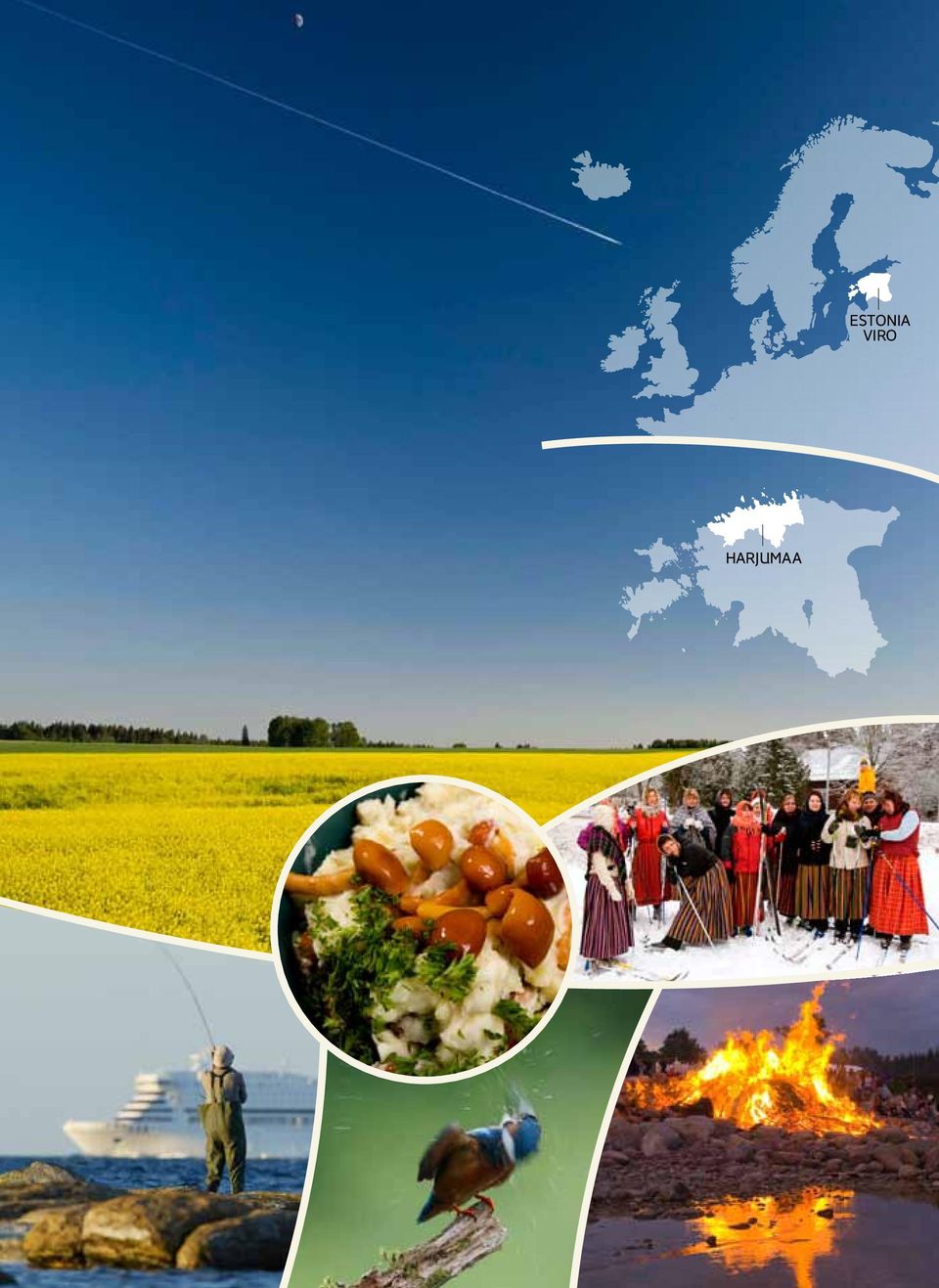
1 ESTONIA VIRO Travel Guide Matkaopas

2 HARJUMAA ESTONIA VIRO
3 CHARACTERISTICS OF NATURE IN THE HARJU COUNTY Harju County is formed of three larger landscape divisions: coastal lowland and islands in front of the limestone bank, cultivated plateau on the limestone bank, forested Kõrvemaa on the limestone bank. The coastal lowland is a coastal product through and through; the main characteristics of the plateau are determined by the occurrence of limestone near the soil and detritions generated by sheet glaciers. Kõrvemaa is characterised by narrow eskers generated by sheet glaciers as well as swampy areas between them. Absolute altitude of ground mainly remains between metres; in Kõrvemaa, it reaches 110 metres. The greatest relative altitudes (30m) occur in some parts of the limestone bank and on the ridges of Kõrvemaa. Lakes are mostly small; the largest one Lake Ülemiste located next to the Tallinn airport can be seen by anyone arriving by plane. The swamps of the Harju County have countless ponds and Kõrvemaa is characterised by picturesque groups of small lakes. About a fifth of the county is covered in swamps and about half in forests. The rest comprises industries, settlements and agricultural land. Landscape on limestone, old coastal formations, karstscapes, bedrock terraces, waterfalls, and abundance of boulders those naturerelated keywords symbolise the differences of the Harju County from the rest of Estonia. 19% of the area of the county is considered as nature preservation areas. Tallinn is the centre of the Harju County and all main roads converge there as rays. Settlement is also mainly concentrated to the vicinity of Tallinn. The population density of the county is 122 people / km² including the capital and 26 people / km² excluding the capital. HARJUMAAN LUONNON OMINAISPIIRTEET Harjun maakunnan luonto koostuu kolmesta suuremmasta maastotyypistä: kalkkikivitörmän edessä olevasta rannikkomatalikosta saarineen, törmän päällä olevasta laakeasta kulttuurimaasta ja samoin törmän päällisestä metsäisestä Kõrvemaasta. Rannikkomatalikko on kokonaan meren luomaa, laakean törmän päällisen tasamaan piirteet ovat pinnan kalkkikiven ja mannerjään kulutukseen liittyviä. Kõrvemaata luonnehtivat mannerjään muokkaamat kapeat selänteet ja niiden väliin jäävät soistuneet alueet. Valtaosin maastokorkeudet meren pinnasta jäävät metriin, Kõrvemaalla se on jopa 110 metriin. Suurimpia korkeuseroja (30 m) esiintyy joillakin rantatörmäalueilla ja Kõrvemaan selänteillä. Järvet ovat enimmäkseen pieniä, Suurimman järven, Ülemisten, lentoteitse saapuja näkee heti Tallinnan lentoaseman vieressä. Harjumaan soissa on lukemattomia suonsilmiä. Kõrvemaalla voi nähdä maalauksellisia pienten järvien vesistöjä. Noin viidennes maakunnan alueesta on soita ja puolet metsiä. Jäljelle jäävä maa on teollisuuden, asutuksen ja maatalouden käytössä. Kalkkikivipohjainen maasto, vanhat rantamuodostumat, karstialueet, kalliojyrkänteet, purot, siirtolohkareiden runsaus kaikki nämä erottavat Harjumaan muusta Virosta. 19 % maakunnan pintaalasta on suojelun alaista. Tallinna on Harjumaan keskus ja kaikki tärkeimmät maantiet johtavat viuhkana sinne. Myös asutus on keskittynyt Tallinnan ympäristöön. Maakunnan asukastiheys pääkaupunki mukaan lukien on 122 as/km², ilman Tallinnaa 26 as/ km².

4 COAST AND LIMESTONE BANK RANNIKKO JA KALKKIKIVITÖRMÄ The almost 400 km long coastline of the Harju County is jointed with numerous peninsulas and bays. The coastal sea is shallow everywhere and it is also mostly full of stones. The coast demonstrates storm-designed beach ridges, wind-ridden sand knobs, wave-washed terraces, and further along, forested sand dunes. Commonly, there are grassy sloping beaches, in bays also beaches overgrown with reeds. Small capes at the ends of peninsulas are usually rocky. River mouths present beaches with sand dunes that attract summer beach vacationers (starting from the West, beaches of Kloogaranna, Vääna-Jõesuu, Tallinn, Valkla and Loksa). The ground of Northern Estonia has risen from the sea during a long period of time, and thus, beach-related landforms can also be found further inland. Now, the border between land and sea has stabilised; in recent times, rather the activity of the sea can be seen in terms of storms occasionally damaging the coast. The Baltic Klint runs throughout the Harju County parallel to the coastline and not far from the sea. This is a large-scale bedrock terrace 30 metres in height from its foothill that reaches far beyond Estonia. The klint is characterised by its exterior versatility. A few klint sections fall vertically into the sea and a collapse threat still exists (Pakri peninsula), at the same time, some terraces have not been directly impacted by the sea and these are high, allowing for open sea views (Türisalu, Rannamõisa and Ülgase cliffs). Several klint sections are covered with later materials and represent simply Harjumaan lähes 400 km pituinen rantaviiva muodostuu runsaista niemistä ja lahdista. Rannikkomeri on kaikkialla matala ja enimmäkseen kivinen. Rantakaistalla on myrskyjen muovaamia rantavalleja, tuulien riepottamia hietikoita ja aaltojen syövyttämiä jyrkänteitä, kauempana metsiin työntyneitä särkkiä. Yleisimpiä ovat ruohottuneet tasaiset rannat ja ruovikoituneet lahdenpoukamat. Niemien kärjet ovat yleensä kivisiä. Jokisuissa on särkkäistä hiekkarantaa, joka houkuttelee rantalomalaisia. Näitä ovat lännestä lukien Kloogarand, Vääna-Jõesuu, Tallinnan, Valklan ja Loksan rannat. Pohjois-Viron maanpinta on pitkän ajan kuluessa noussut merestä, siksi rannan pintamuotoja esiintyy myös kauempana sisämaassa. Nykyisellään maan ja meren raja pysyy ennallaan, viime aikoina on huomattu meren vaikutuksen kasvavan, kun myrskyt paikoin murtavat rannikkoa.

5 steeper slopes. The klint comprises Cambrian and Ordovician rocks (clays, sandstone and limestone) that form the geological foundation of Northern Estonia. The generally regular-shaped klint line is made interesting by bedrock peninsulas (Viimsi), bays (Keila-Joa) and separate klint islands (Toompea in Tallinn). An attractive outcrop of the klint is on the Pakri peninsula, where one can see a several kilometres wide cross-section of the seabed deposited over 50 million years. The Baltic Klint has been presented as a candidate to the UNESCO World Heritage List as a monument of primeval wildlife. The vicinity of the capital conditions relatively intensive use and settlement of beach areas in the Harju County, because a home or summer cottage at the beach is a dream for many. Still, there are beaches in the Harju County, which has high population density in terms of Estonia, where one can walk for kilometres without noticing any signs of settlement (Pakri, Muraste, and Kaberneeme). Generally, beaches are open to everyone and restricted only at some urban areas and harbours. Rantaviivan kanssa samansuuntaisena eikä kaukana merestä ulottuu Harjumaan läpi Baltian klintti. Se on juurelta mitattuna 30 metriä korkea törmä, joka ulottuu kauas Viron ulkopuolelle. Sen erikoisuutena on monimuotoisuus. Osa törmistä laskeutuu pystysuoraan mereen ja ovat myös vyörymien vuoksi vaarallisia (Pakrin niemi), osaan taas meri ei vaikuta mitenkään. Niiden korkeuksista on tarjolla avaria merinäkymiä (Türisalun, Rannamõisan ja Ülgasen törmät). Monet törmän alueet ovat muun maa-aineksen peittämiä ja siksi niiden rinteet ovat loivempia. Klintissä on näkyvissä Kambriumja Ordoviki-kauden kivettymiä, savia, hiekka- ja kalkkikiviä, jotka ovat Pohjois-Viron geologinen perusta. Muuten säännöllistä klinttiä elävöittävät niemet (Viimsi), lahdet (Keila-Joa) ja erilliset klinttisaaret (Toompea Tallinnassa). Erityisen kiintoisa klintti on Pakrin niemellä, jossa monen kilometrin matkalla aukeaa läpileikkaus noin 50 miljoonan vuoden aikana kerrostuneesta meren pohjasta. Baltian klinttiä on ehdotettu Unescon maailmanperintökohteeksi. Pääkaupungin läheisyys vaikuttaa Harjumaan rantojen käyttöön ja asutukseen, kun merenranta-asunto on monien unelma. Silti Harjumaalla riittää rantoja, joilla voi kävellä kilometrikaupalla tapaamatta asutuksen merkkejä (Pakri, Muraste, Kaberneeme). Yleensä rannoilla liikkuminen on kaikille vapaata, vain asuinalueiden ja satamien kohdalla on rajoituksia. Out of the 10 largest boulders in Estonia 7 are situated in the Harju County. The biggest of them with the size of 728 m³, called Muuga Kabelikivi (Muuga Chapel Rock) in the Viimsi Parish is the second largest in Estonia. Viron 10 suurimmasta siirtolohkareesta 7 sijaitsee Harjun maakunnassa. Näistä suurin, kooltaan 728 m³, on Muugan Kabelikivi (Kappelikivi) Viimsin kunnassa on Viron toiseksi suurin.

6 ISLANDS SAARET The Harju County includes about 75 islands, many of which are so small they do not even have a name. Permanent settlement can be found on five islands: some people live on Naissaar, Aegna, Suur- and Väike Pakri; Prangli has the most people (170 people). In addition, there are vacationers in the summer. A few households have also been restored on some smaller islands (Koipsi, Rammu). At earlier times, settlement on islands was far denser, several of them has a school and a church. In the 20th century however, the islands were destined by their strategic positions. Firstly, people were forced to leave in relation to the construction of the tsarist Russian sea fortress before the First World War (Aegna and Naissaar), afterwards in connection with the events of the Second World War and the following period when the border zone of the Soviet Union was emptied of people. For a long time, the Pakri islands were used for airbase purposes and Naissaar as naval mine storage. Those islands finally became free of foreign armed forces in Among the islands with settlements, natural development has been possible only on Prangli. But permanent population has diminished here many-fold as well. The popular summer vacation spot Aegna at the gate of Tallinn was opened for civilians in the 1960s. Naissaar, with the virgin forest nearest to Tallinn has gained pop- Harjun maakuntaan kuuluu noin 75 meren saarta, monet ovat niin pieniä, ettei niillä ole nimeä. Pysyvää asutusta on viidellä saarella: muutamia asukkaita Naissaarellä, Aegnalla, Suur- ja Väike-Pakrilla, suurin asutus on Pranglilla, 170 asukasta. Kesällä määrä kasvaa kesäasukkailla. Muutamia asuntoja on pienillä saarilla, kuten Koipsilla ja Rammulla. Aikaisemmin asukkaita oli saarilla enemmän, monella oli koulu ja kirkko luvulla strateginen asema oli kohtalokas. Väestö pakotettiin muuttamaan tsaari-venäjän merilinnoituksen tieltä ennen ensimmäistä maailmansotaa Aegnalta ja Naissaarelta. Toisen maailmansodan vuoksi ja sen jälkeen Neuvostoliiton rajavyöhyke tyhjennettiin ranta-asukkaista. Pakrin saaret olivat ilmavoimien harjoitusalue ja Naissaar laivaston miinavarasto. Saaret vapautuivat vieraista joukoista lopullisesti vuonna 1993.

7 The Harju County has over 300 km of coastline and 75 islands and islets. The biggest island is Naissaar (Woman s Island, 18.5 km²), which is also the biggest island in the Gulf of Finland. There is still some primeval forest preserved on Naissaar. Harjumaalla on yli 300 km rantaviivaa sekä 75 saarta ja luotoa. Suurin on Tallinnan lähistön Naissaari (18,5 km²), joka on myös Suomenlahden suurin saari. Siellä on säilynyt ikimetsää. ularity in latest years with classical music concerts. Those are the three islands with regular water traffic, although all-year-round traffic only operates to Prangli. All other islands in the Harju County can be reached by smaller vessels or in winter, by walking across ice. The islands are located quite near the coast and are often visible. In terms of nature, the islands of the Harju County are very versatile. Some of them only represent wavewashed stone fords that are only inhabited by birds. The highest island Naissaar, reaching up to 27 metres in the centre, is the oldest Estonian island in the Gulf of Finland, which started rising from the sea about 7000 years ago. The relief and surface are washed and polished by the sea. Generally, larger islands are rick in forests, even the waterfront pastures are overgrowing today. Shallower islands are still under the influence of the sea, which is why these are covered in heaths and meadows. The abundance of boulders is characteristic to all islands. The Pakri islands differ from others by their limestone bedrock and the related klint terraces. Asutetuista saarista normaali kehitys on voinut jatkua vain Prangilla. Pysyvä asutus on kuitenkin kovasti vähentynyt. Tallinnan edustan suosittu kesänviettopaikka Aegna avattiin siviileille vuonna Naissaari, jolla kasvaa Tallinnan lähin ikimetsä, on viime vuosina saanut mainetta klassisen musiikin konserteistaan. Näihin kolmeen saareen on säännöllinen laivayhteys, ympäri vuoden vain Pranglille. Muille saarille pääsee vain pienaluksilla tai talvella jäitse. Saaret ovat lähellä rannikkoa ja usein nähtävissä. Luonnoltaan Harjumaan saaret ovat moninaisia. Jotkut ovat vain kivikoita, joiden yli aallot lyövät ja joilla vain linnut asustavat. Korkein on keskiosaltaan 27 m korkea Naissaar, joka on vanhin Viron Suomenlahden saarista. Se alkoi nousta merestä noin 7000 vuotta sitten. Pintamuoto ja itse pinta on meren pesemää ja hiomaa. Yleensä suurimmilla saarilla kasvaa metsää, aikaisemmat rantalaitumetkin ovat metsittymässä. Matalammat saaret ovat jatkuvasti meren armoilla, ne ovat valtaosin nummia ja niittyjä. Siirtolohkareet ovat tunnusomaisia kaikille saarille. Pakrin saarella on kalkkikiviperusta ja sen klinttitörmä, jotka poikkeavat muista saarista.

8 RIVERS, WATERFALLS, KARST AREAS JOET, PUTOUKSET, KARSTIALUEET The Harju County has about ten rivers flowing into the sea and these have sufficient water for conducting water trips. When generally, Northern Estonian rivers flow slowly and with large bends, then upon arriving at the klint edge, they are suddenly in a hurry. Rivers descending from cliffs are in their lower reaches characterised by waterfalls, terraces, rapids and canyon valleys. The height of the most vivid waterfalls remains between 2-7 metres and during high-water, these offer fascinating spectacles. The county has about twenty known waterfalls, of which the richest in water are (starting from the west) Treppoja, Keila, Vääna, Jägala, Nõmmeveski, and Joaveski. Figuratively, people speak about the waterfall belt of Northern Estonia as due to klint terraces, the chain of waterfalls also continues in the direction of the Viru County. Waterfalls are usually followed by a longer section of rapids, after which the rivers calm upon reaching the sea. Some of the rivers in the Harju County (Keila, Pirita) flow mostly on cultivated land, and thus people have the opportunity of enjoying historical watermills and manor estates on their banks. But some rivers (Jägala, Valgejõgi) pass through massive forest areas, where people are a rare sight. In spring, the rivers are full of canoeists and some fishermen can be found at reservoirs. Perch, roach, pike and bream are the most common fish to catch. A simple rule about Estonian rivers is that the spring high-water is ten times higher and the summer low-water is ten times lower than the average water levels of the year. River banks are open to everyone, but hikers also have to take the land owners interests into account. Harjumaalla mereen laskee kymmenisen jokea, joiden vesimäärä mahdollistaa niillä retkeilyn. Kun Pohjois- Viron joet normaalisti virtaavat hitaasti, klintin reunalla niiden virtaama kiihtyy. Törmärannikolta laskevien jokien alajuoksulle ovat tyypilliset putoukset, törmät, kosket ja kanjonilaaksot. Putouksien korkeus vaihtelee 2-7 metriin, tulva-aikaan ne tarjoavat jännittävää katseltavaa. Maakunnassa on parikymmentä putousta, joista runsasvetisimpiä lännestä lukien ovat Treppoja, Keila, Vääna, Jägala, Nõmmeveski, Joaveski. Puhutaan jopa Pohjois-Viron putousvyöhykkeestä, koska klintin reunassa putouksia riittää aina Virumaalle asti. Putouksien jälkeen joessa on tavallisesti pitkä koskialue, jonka jälkeen vesi virtaa rauhallisemmin ennen mereen laskemistaan. Osa Harjumaan joista, kuten Keila ja Pirita, virtaavat kulttuurimaiseman läpi. Siksi niiden rannoilla on historiallisia myllyjä ja kartanoita. Osa joista, kuten Jägala ja Valgejõgi kulkevat suurten metsien läpi, siellä ei juuri ihmisiä tapaa. Keväisin joilla liikkuu melojia, onkijoita tapaa tulvajärvien rannoilla. Tavallisimmat pyyntikalat ovat ahven, särki, hauki ja lahna. Viron joissa pätee sääntö: keväinen tulvavesi on kymmenkertainen ja kesän vesi alimmillaan kymmenesosa vuoden keskimääräisestä vesimäärästä. Kulkeminen jokirannoilla on kaikille sallittua, mutta retkeilijän on huomioitava maanomistajain oikeudet.

9 Due to the location of limestone near the soil, several rivers present karst formations: gullies, caves, collapse coves, rudimentary stone beds, and underwater river sections. Karsts, which mean the dissolution of calcareous rocks due to flowing water, are common in many places in the Harju County, more so in Kostivere, Kuivajõgi, and Tuhala. Karsts in turn are connected to a number of springs, because the water subdued into the soil through the holes also has to find its way out. Karst springs are characterised by direct dependence on rain and melting snow the springs will actively come alive in watery periods, for example, the Tuhala witch well simply overflows. However, dry periods are quiet in karst areas, because the water flows nicely underground and so the springs are also calm. Kalkkikiven ollessa maan pinnassa monilla joilla näkyy karstimuodostelmia: uurteita, luolia, vajoamia, esiin pistäviä kivitörmiä ja maanalaisia jokialueita. Karsti eli karbonaattikiven liukenevien aineiden syöpyminen virtaavan veden vaikutuksesta on yleistä monin paikoin Harjumaalla, näkyvimmin Kostiveressä, Kuivajõella, Tuhalassa. Monet lähteet ovat karsti-ilmiön seurausta, sillä veden, joka imeytyy onkaloiden kautta maahan, pitää löytää ulospääsy jostain muualta. Karstilähteet ovat suoraan riippuvaisia sateesta ja lumen sulamisvedestä vetisinä kausina ne heräävät eloon voimallisesti. Esimerkiksi Tuhalan Noidankaivossa vesi suorastaan tulvii ulos kaivosta. Kuivana aikana karstialueella on hiljaista, sillä vesi mahtuu virtaamaan maan alla ja lähteet käyttäytyvät rauhallisesti. 34 rivers and other flowing bodies of water flow into sea in the Harju County. The falls on the rivers Jägala and Keila are the most picturesque and one of the largest and the most abundant in water in Estonia. The Dutch newspaper DE Telegraaf has chosen Jägala Falls as one of the 10 most beautiful falls in the world. Harjun maakunnan rannikolla mereen laskee 34 jokea ja puroa. Jägalan ja Keilan jokien putoukset ovat kaikkein maalauksellisimmat ja eräät Viron suurimmista. Hollantilainen De Telegraaf-lehti on valinnut Jägalan putouksen maailman 10 kauneimman putouksen luetteloonsa.

10 LANDSCAPE AND BIOTA MAASTO JA ELIÖT Regardless of the impact of Tallinn, the capital, the forestation (52%) of the Harju County is more or less an Estonian average. This is due to large forested areas in the eastern and western parts of the county that also continue further out of the county. The most common forest tree is pine, followed far behind by birch and fir. Smaller oak-forests are rarer and mostly, these are nature preservation areas. Fascinating communities can be found in old manor parks (e.g. Keila-Joa). One certain characteristic of the Harju County is the extensive occurrence of alvars (meadows with thin soil surface on limestone) (e.g. at the Rebala heritage reserve and in the Vääna area). Namely, the first Estonian permanent settlements or native villages developed on alvars in ancient times. In Estonian, more such landscapes can be found on the island of Saaremaa. The most common inhabitants of forests in the Harju County are wild boar, beaver, moose, and roe deer. The populations of lynx and wolves are widening, notices about bears wandering in the forested regions of the county occur from time to time. Nature preservation measures have improved the nesting success of some eagles (e.g. white-tailed eagle and golden eagle); the decreasing population of great grouse is worrisome. The abundance of, first and foremost, sea and migrant birds (e.g. swans, sea swallows, goldeneye, and longtailed duck) has given grounds for the formation of bird areas in Lahemaa, at the Pakri peninsula and the Kolga bay that have international significance. Pääkaupungin Tallinnan vaikutuksesta huolimatta Harjun maakunnan pinta-alasta on metsää 52 %, joka on Viron keskitasoa. Tämä johtuu maakunnan itä- ja länsiosien suurista metsäalueista, jotka ulottuvat kauas maakunnan ulkopuolelle. Valtapuu on mänty, vähemmässä määrin koivu ja kuusi. Harvinaisia ja tavallisesti suojeltuja ovat pienehköt tammistot. Mielenkiintoisia puita kasvaa vanhoissa kartanopuistoissa, kuten Keila-Joalla. Harjumaan erikoisuus ovat alvarit eli ohuen multakerroksen peittämät kalkkikivipohjaiset niityt esimerkiksi Rebalan muinaismuistosuojelualueella ja Väänan seudulla. Juuri alvareille syntyiväti Viron ensimmäiset pysyvän asutuksen muinaiskylät. Virossa on tätä maastotyyppiä vielä runsaammin Saarenmaalla. Harjumaan metsien yleisimpiä asukkeja ovat villisika, majava, hirvi ja metsäkauris. Ilveksen ja suden kanta on kasvussa, välistä kuulee karhun eksymisestä rintamaille metsäisiltä reuna-alueilta. Suojelutoimet ovat parantaneet esim. meri- ja maakotkan pesintää, metson kanta on huolestuttavasti vähenemässä. Varsinkin meri- ja muuttolintujen runsaus (joutsenet, tiirat, telkkä, alli) on vaikuttanut Lahemaan, Pakrin niemen ja Kolgalahden lintualueiden syntyyn. Niitä pidetään kansainvälisestikin merkittävinä. The fattest tree in the Harju County is the Oak of Liivaaugu in the Keila Parish, with the circumference of 7 metres. Harjumaan paksuin puu on Keilan kunnassa kasvava Liivaaugun tammi, jonka läpimitta on 7 metriä.
.")
11 WESTERN HARJU COUNTY LÄNSI- HARJUMAA The western part of the Harju County holds the wide Suursoo (Great Swamp). It is a 200 km² wetland that continues also in the Lääne County. The landscape of Suursoo is characterised by the alternation of heaths and bogs that is very pronounced near Tänavjärv. The sand-banked lake in the middle of a bog is relatively large (137 ha) and has clear water. As it mainly feeds on rainfall, the water is mild and the lake hosts several rare plants (e.g. water lobelia). The massive of Suursoo has designed a historical border for the Harju County, because settlement is very sparse there. This area is characterised by coastal formations, eskers and heath forests expanding on beach sand; this is complemented by some typical heath landscape. The plain areas between higher landforms are dominated by swamps. The large proportion of dry pine forests bring about frequent forest fires in the area. In Lääne-Harkumaa, settlements can be found on coastal areas. Smaller roads offer beautiful views of the sea (e.g. Keibu, Alliklepa). Generally, the coast is level, but terraced coast can be found in Vintse and Pedase. The long-time historical centre of the area is Padise with its several historical and architectural monuments (e.g. ancient settlement site, monastery ruins, manor). Harjumaan länsireunalla on laaja 200 km² suuruinen Suursoo ja se jatkuu aina Läänemaalle asti. Sen maasto vaihtelee nummena ja rämeenä, erityisesti Tänavjärven lähistöllä. Keskellä rämettä olevan hiekkarantaisen järven pinta-ala on 137 ha ja vesi kirkasta. Se saa vetensä lähinnä sateista ja siksi vesi on pehmeää. Järvessä kasvaa monia kasviharvinaisuuksia, kuten nuottaruoho. Suursoon koko on vaikuttanut mm. siihen, että asutus on hyvin harvaa. Aluetta ilmentävät rannikkomuodot, selänteillä ja meren hietikoilla kasvavat nummi- ja kangasmetsät sekä tyypilliset nummet. Korkeampien pinnanmuotojen välisillä tasaisilla alueilla on pääosin soita. Kuivien männiköiden suuren osuuden vuoksi alueella on usein metsäpaloja. Länsi-Harjumaalla asutusta on runsaammin rannikoilla. Pieniltä teiltä aukeaa kauniita näkymiä merelle, kuten Keibussa ja Alliklepassa. Yleensä rannikko on tasainen, mutta Vintsessä ja Pedasessa porrastunutta. Alueen historiallinen keskus on kauan ollut Padise, jossa on monia historiallisia ja arkkitehtuurimuistomerkkejä, kuten linnanmäki, luostarin rauniot ja kartano. Lake Valgejärv (White Lake) in the western part of the Harju County is unique in Estonia. The lake has the depth of only 1 metre, but the bottom of the lake is covered with 2-3 metres layer of lime. Lime is brought to the lake by springs rich in lime. Länsi-Harjumaalla sijaitseva Valgejärv on Virossa ainutlaatuinen. Sen syvyys on vain 1 metri, mutta sen pohjaa peittää 2-3 metrin paksuudelta järvikalkki. Kalkki on ilmeisesti peräisin järveen virtaavista kalkkirikkaista lähteistä.

12 KÕRVEMAA In the eastern part of the Harju County lies the Kõrvemaa Landscape Reserve, which is part of the belt of forests and wetlands that passes through the whole Estonia. Influential natural conditions for the development of landscapes in Kõrvemaa have been flat landforms, complex alternation of eskers and hills and the gathering of excessive moisture due to the lack of drainage. Kõrvemaa is sparsely populated and still becoming less populated. Once the marsh islands were inhabited due to lack of land, but they have become empty now. Therefore Kõrvemaa is a true paradise for hikers. Former farm roads have become hiking tracks. North-Kõrvemaa is becoming more and more known and popular among nature lovers. Only a few decades ago a large part of Kõrvemaa (130 km²) was the Soviet army polygon and closed to visitors. Today this territory is covered with several hiking trails. The uniqueness of North-Kõrvemaa lies in its varied landforms (e.g. many chains of eskers, high dome-shaped flat hills, sandy fields) and abundance of lakes. Altogether there are 40 lakes, including some sandy-bottomed lakes with clear water. The largest Estonian heath (around 100 ha) in Jussi Mountains offering the most panoramic views has been formed as a result of forest fires and army shooting exercises. In the primeval-looking but at the same time quite easily passable landscape traces of the former marsh and winter paths are hidden. The essence of Kõrvemaa landscapes from 100 years ago has been recorded in the books written by the Estonian author A.H. Tammsaare. Hillocks with an interesting relief, which are appreciated by skiers and orienteers, can be found in Aegviidu, Voose, and Paunküla. Aegviidu-Nelijärve area surprises hikers both in summer and in winter. From Voose starts an imposing looking up to 5 km long esker, part of which is also a magnificent former stronghold site. In Paunküla the visitor can admire several small lakes and steep slopes of glacial landforms alongside the lakes. Paunküla is one of the favourite places of Tallinn fishermen. Harjumaan itäosassa on Kõrvemaan alue, joka on osa koko Viron halki ulottuvasta laajasta metsien ja soiden vyöhykkeestä. Maaston muotoutumisen lähtökohtana on ollut tasainen pintamuoto, selänteiden ja kumpujen mutkikas vaihtelevuus ja virtaamien estymisestä aiheutuva märkyys. Asutus on täällä erittäin harvaa ja harvenee edelleen. Aikoinaan maan vähäisyyden vuoksi käyttöön otetut suosaaret ovat nykyiselleen autioituneet. Siksipä Kõrvemaa on nykypäivän retkeilijäin paratiisi. Entiset maatilojen tiet ovat nyt retkipolkuja. Pohjois-Kõrvemaa kasvattaa nopeasti luontoharrastajain suosiota. Vielä parikymmentä vuotta sitten siitä 130 km2:n suuruinen alue oli neuvostoarmeijan harjoitusalueena vieraille suljettua. Nyt aluetta halkovat monet retkipolut. Pohjois-Kõrvemaan erityisyys on sen vaihtelevissa pinnanmuodoissa ja järvien runsaus. Näitä ovat selänneketjut, laakeat kukkulat ja hietikot. Järviä on kaikkiaan 40, joista muutamat ovat hiekkapohjaisina kirkasvetisiä. Mainioita näkymiä tarjoava Viron suurin, lähes 100 ha suuruinen kanervanummi Jussin mäillä on syntynyt armeijan ampumaharjoitusten ja metsäpalojen seurauksena. Ikimetsämäisessä, mutta helppokulkuisessa maastossa näkyy vielä jälkiä vanhoista suo- ja talviteistä. Virolainen klassikkokirjailija A. H. Tammsaare on tuotannossaan ikuistanut Kõrvemaan maisemia sellaisina, kun ne olivat sata vuotta sitten. Mielenkiintoisen muotoiset kukkulajonot ovat suunnistajain ja hiihtäjien suosimia. Niitä on myös Aegviidussa, Voosesa, Paunkülassä. Aegviidun-Nelijärven alue yllättää retkeilijöitä kesin, talvin. Voosesta alkaa näyttävä, jopa 5 kilometrin pituinen selänne, jonka osana on vaikuttava linnanmäki. Paunkülässä pienellä alueella vaihtelevat monilukuiset pienet järvet ja jäätikön muokkaamat jyrkkärinteiset maastomuodot. Paunkülä on tallinnalaisten harrastuskalastajain lempipaikkoja.

13 LAHEMAA The name of the Lahemaa National Park as well as its uniqueness is derived from its indented coastline, where rocky peninsulas alternate with hidden bays. Historical fishermen villages can be found along the coastline, nowadays these are recreation areas with summer cottages. Between villages lie strips of forest or reed thickets. Further from sea and behind the coastal sand dunes settlement becomes quite sparse. This is the region of marshes and ancient marsh forests. Villages with larger arable fields can be found on the flat land on the klint in the areas of Muuksi, Kahala, Uuri and Kolgaküla. Klint, which divides Lahemaa into half in the east-west direction, is the other great landscape form beside the sea that has shaped nature in this region. Waterfalls and rapids of Nõmmeveski and Joaveski together with Muuksi terrace give hints about the course of the klint. Further south Lahemaa is joined by Kõrvemaa forests and the population becomes sparse again. The main value of Lahemaa is its natural diversity juniper fields, alvars, cliff forests, pine forests full of light and marshes. Beside natural values Lahemaa is rich in archaeological sites and old villages, manors and museums. Magnificent sea view opens from the Muuksi stronghold hill, nearby lies a large area of stone barrows. The rocky end of Pärispea Peninsula, which stretches far into the sea, marks the northern most spot of Estonian mainland. Among many erratic boulders in Lahemaa Majakivi (House Stone) in Juminda forest is the third largest boulder in Estonia (cubage 584 m³). The Lahemaa National Park is the oldest in Estonia (established in 1971) and therefore a lot of work has been done here for receiving visitors and for restoration of historical buildings. Lahemaan kansallispuiston luonne ja nimi johtuvat sen polveilevasta rantaviivasta, jossa kiviset niemet ja varjoisat lahdet vaihtelevat. Rannassa on paikoitellen historiallisia kalastajakyliä, jotka nykyisin ovat valtaosin lomailukylinä. Välistä on vyöhykkeittäin metsää tai ruovikkoa. Merestä kauempana ja rantadyynien takana asutusta on niukasti. Täällä näemme soita ja ikimetsämäisiä suometsiä. Jälleen tulee vastaan kyliä, mutta nyt suurempine peltoaukeineen klintinpäälisellä tasamaalla - Muuksin, Kahalan, Uurin ja Kolgakülan seuduilla. Klintti, joka puolittaa itä-länsisuunnassa Lahemaan, on meren ohella toinen täkäläistä luontoa muokannut tekijä. Lahemaan jokien Nõmmeveskin ja Joaveskin kosket yhdessä Muuksin putouksen kanssa ovat merkkejä tästä. Kauempana etelässä Lahemaa yhtyy Kõrvemaan metsiin ja asutus harvenee. Lahemaan suurin rikkaus onkin sen maastollinen monipuolisuus katajikot, kalliopohjaiset jyrkännemetsät, valoisat männiköt ja suot. Näiden lisäksi vielä arkkitehtoniset muistomerkit, muinaiskylät, kartanot ja museot. Muuksin linnanmäeltä avautuu loistava merinäköala, sen lähellä on laaja kivikalmistoalue. Pärispean niemen kivinen nokka, joka ulottuu kauas merelle, on Viron mantereen pohjoisin piste. Lukuisten siirtolohkareiden joukosta mainittakoon Jumindan metsien kainalossa Majakivi, joka 584 m³:n tilavuuksineen on Viron kolmanneksi suurin. Lahemaan kansallispuisto perustettiin vuonna 1971 eli se on Viron vanhin. Siksi Lahemaalla on tehty paljon vierailijain viihtymiseksi ja myös historiallisten rakennusten entistämiseksi.

14 ON THE WATER VESILLÄ Sea tourism The indented coastline of the Harju County with the abundance of islands in the coastal region has always fascinated yachtsmen and also those riding on motorboats, scooters, sailboards, sea kayaks or even more exotic types of sea transport. The unofficial world record of the kayak rider Johannes Maide from 1921 marks the symbolic beginning of the Estonian sea tourism. He begun and ended his ride in the Pirita Yacht Harbour in Tallinn, and passed alone the route of 1046 km around Estonia. Mostly the journey went along the coastline, but partially also on rivers and lakes. The Baltic Sea is quite safe for sea riders. In the summertime the visibility on the sea is good and the wind speed is less than during the wintertime. In the shallow coastal waters the rider has to be aware of shoals and rocks, which are mostly marked on the sea maps, but may still offer unpleasant surprises. The average sea level fluctuates around cm over months, due to the general circulation of the atmosphere. The rise caused by tides is minimal (up to 5 cm), and the sea has no significant currents. The general movement of streams in the Gulf of Finland runs against clockwise. The freezing of the sea, especially in the small bays, starts from the eastern direction. The total freezing of the Gulf of Finland occurs only 3-4 times a century. Besides the ports in Tallinn there are two other ports in the Harju County which offer customs and border services (in Paldiski and in Lohusalu), but there are several smaller ports and places for beaching (see the map at page 34). The services offered in these smaller ports vary. Due to the ruling west winds, most ports are situated in the eastern sides of peninsulas or islands. There may be temporary seasonal moving restrictions on smaller islands and islets (during the nesting of seabirds or seals). In some areas near swimming places or sensitive bird nesting regions riding on scooters is limited. More info: marinas.nautilus.ee; sadamateliit.ee Veneily Harjumaan mutkitteleva rantaviiva ja runsassaarinen meri on aina kiehtonut purjehtijoita ja muita merellä liikkujia oli aluksena sitten moottorivene, vesiskootteri, purjelauta, kanootti tai jotain vielä eksoottisempaa. Virolaisen merimatkailun symboli on kanoottiretkeilijä Johannes Maiden epävirallinen maailmanennätys vuodelta Hän aloitti ja lopetti retkensä Tallinnan venesatamassa, meloi yksin 1046 kilometrin matkan Viron ympäri. Valtaosin reitti kulki pitkin rannikkoa, mutta osaksi pitkin jokia ja järviä. Itämeri on merenkulkijalle melko turvallinen. Kesällä näkyvyys merellä on hyvä ja tuulen nopeus pienempi kuin talvella. Rannikon lähellä on liikkujan huomioitava matalikot ja kivet, jotka kyllä on merkitty merikortteihin, mutta voivat silti yllättää. Veden korkeus vaihtelee kuukausittain cm lähinnä ilmakehän virtausten aiheuttamana. Vuoroveden vaikutus on olematon, enintään 5 cm. Meressä ei samoin ole voimakkaita virtauksia. Virtaukset kulkevat Suomenlahdessa vastapäivään. Meren jäätyminen ennen kaikkea lahdenpoukamissa alkaa idästä. Suomenlahti jäätyy kokonaan 3-4 kertaa vuosisadassa. Tallinnan satamien ohella Harjumaalla on kaksi rajavartio- ja tullipalveluja tarjoavaa satamaa Paldiskissa ja Lohusalussa. Pienempiä satamia ja rantautumispaikkoja on tietysti enemmän. Katso karttaa sivulla 34. Näiden tarjoamat palvelut ovat vaihtelevia. Merellä enimmäkseen puhaltavien länsituulien vuoksi valtaosa satamista on niemillä tai saarten tuulensuojassa eli itäpuolella. Joillakin pienimmillä saarilla voi olla kausiluontoisia kulkurajoituksia, syynä on merilintujen pesintä ja hylkeet. Joillakin alueilla uimapaikkojen ja herkkien lintualueiden lähellä vesiskoottereilla ajelu on rajoitettua. Lisätietoa:

15 Water hiking Of all the rivers in the Harju Country canoe and boat riders prefer Jägala, Pirita and Valgejõgi. These rivers, being the largest in the Harju County are around 100 km long and enable peaceful and slow rides for 2-3 days. There are several shorter rivers, but their supply of water allows riding only on limited distances. The slow flow of all the rivers in the Harju County is cut off when descending the klint (North Estonian Cliff), creating rapids and waterfalls. The same occurs at dams that often mark the sites of historical watermills, manor parks, and industrial buildings. The water from the rivers Jägala and Pirita is partly directed through canals to Tallinn to be used as drinking water. Mostly there are no stationary camping sites for water hikers, but basically stopping is possible everywhere at the riverbanks. Therefore, one just needs to find a suitable private camping site. In the summertime, with low water flow, riding on rivers is easier and suitable also for amateur sportsmen. The springtime with high water has its dangers and it is wise to be careful in the rapids. The peak of high water is during the ice run (March-April), and therefore the best time for water hiking is the following period (April- May) with still high enough water. The visibility is also good in spring, as the trees do not have leaves yet. In the summertime during the drier season river water is good for swimming, but may not be high enough for a boat ride. Another valued period for boat rides is autumn with its colourful leaves and moderate water flow. (see map at page 18) Sisävesiretket Harjumaan kanootti- ja veneretkeilijäin suosikkeja ovat Jägala, Pirita ja Valgejõgi. Nämä Harjumaan suurimmat joet ovat keskimäärin 100 km pitkiä ja 15 m leveitä ja niillä voi tehdä 2-3 päivän rauhallisia retkiä. Lyhyempiäkin jokia on, mutta niiden veden määrä rajoittaa kulkutaitojen hiomisen vain rajatuille kohdille. Kaikkien Harjumaan jokien hidas virtaus kiihtyy klintiltä laskeutumispaikoissa, joissa on koskia. Samoin on laita patojen kohdalla, jotka ovat merkkeinä vanhoista vesimyllyistä, kartanonpuistoista ja teollisuudesta. Jägalan ja Piritan jokien vettä johdetaan kanaalien kautta Tallinnan juomavedeksi. Pysyviä pysähdyspaikkoja ei yleensä ole. Periaatteessa jokien rannoille saa pysähtyä vapaasti, tulee vain itse etsiä sopiva paikka. Kesäisin matalan veden aikaan on jokiretkeily kansanurheilua. Keväällä tulva-aikaan on omat uhkansa ja koskipaikoissa on oltava varovainen. Vedet ovat korkeimmillaan useimmiten jäiden lähtöaikaan maalis-huhtikuussa. Siksi paras aika vesiretkeilyyn on aivan sen jälkeen huhti-toukokuussa. Keväällä näkyvyys on hyvä, kun puut ovat vielä lehdettömiä. Kesällä kuivempana aikana jokivesi käy uintiin, mutta retkeilyyn vettä on niukalti. Syksyn ruska ja kohtuullinen veden määrä suosivat vesiretkeilyä. (Ks. kartta s. 18) Natural gas has been found on Prangli and Keri Islands. On Prangli Island the gas is only 6-7 metres from the surface. Some drill holes have been left open and visitors can try how the gas burns. This is the only natural gas source in Estonia. The lighthouse on Keri Island used gas as a power source and it is the only seamark in the world that has used natural gas. Pranglin ja Kerin saarilla esiintyy maakaasua. Pranglilla kaasu on vain 6-7 metrin syvyydessä. Jotkut porausaukot ovat avonaisia, joten jokainen voi itse kokeilla kaasun palamista. Tämä on Viron ainoa maakaasuesiintymä. Kerin saaren majakka toimi kaasulla ja se on maailman ainoa luonnonkaasulla toiminut merimerkki.
, creating rapids and waterfalls.")
16 ON THE LAND MAALLA Hiking There are plenty of opportunities to practice the oldest means of getting around in the Harju County. There are several smaller roads with few cars if one goes further from Tallinn. Nearby settlements amateur sportsmen will find a fast developing network of smaller concrete paths for running, Nordic walking or rollerskating. For those who yearn for more privacy, the State Forest Management Centre (RMK) has built simpler hiking tracks in many beautiful countryside regions of Estonia. Along the tracks one will find information boards, camping sites and shelters. The length of the tracks varies from 1-10 kilometres; the longest track in the Harju County is 36 km long Liiapeksi-Aegviidu track. In 2012 RMK created a unified track passing through Estonia from north to south (goes through the Harju County as well). This track is 370 km long and ranges from the Lahemaa National Park until the border of Latvia. Main natural obstacles for those moving by foot in the Harju County are occasional small floods. Therefore it is wise to use boots or rubber boots in springs and autumns. Naturally, one should get to know the maps of the region before hiking. Maps suitable for hikers are available from the scale 1: The network of hiking tracks in the Harju County is quite dense and thus hikers do not disturb each other. Often one can move on the hiking tracks without seeing another person. More info: Bike hiking The network of official bicycle lanes nearby towns and smaller settlements in the Harju County is quite dense and growing. Mostly these lanes run parallel to motorways and connect larger centres. Further from heavy traffic on smaller gravelly paths in forests and villages one can feel himself as a true explorer. Riding even deeper into the forests of the Harju County on a mountain bike one may reach quite far from the civilization. In order to arrive to a set destination cyclist can always choose a bypath. The bypath may be longer than the direct way but guarantees a more peaceful ride and enables getting to know the surrounding nature. Bicycle rentals can be found at some tourism farms and manors. Retket jalkaisin Vanhinta kulkumuotoa voi Harjumaalla harrastaa kyllin. Sivuteitä, joilla autoja kulkee harvoin, on Tallinnasta kauempana runsaasti. Asutuskeskusten lähelle on viime vuosina rakennettu kuntoilijoille tarkoitettuja kevyen liikenteen väyliä. Omaa rauhaa kaipaaville on tarjolla retkipolut, joita Riigimetsa Majandamise Keskus RMK (Valtionmetsien hallintakeskus) on rakentanut luonnonkauniille paikoille. Poluilla on tietotauluja, nuotiopaikkoja ja katoksia. Polkujen pituus vaihtelee 1-10 kilometriin. Harjumaan pisin on 36 km pitkä Liiapeksin- Aegviidun polku. Vuonna 2012 RMK yhdisti yhtenäiseksi poluksi Viron ja tietysti Harjumaankin läpi kulkevan 370 km pituisen reitin Lahemaan kansallispuistosta Latvian rajalle. Suurin luonnon aiheuttama häiriötekijä samoilijalle saattaa olla liiallinen veden runsaus eli tulviminen. Keväisin ja syksyisin ovat kumisaappaat tai muut tukevat jalkineet tarpeen. Karttoihin kannattaa tietysti tutustua ennakolta. Retkeilijöille sopivia karttoja on saatavilla mittakaavasta 1: alkaen. Yleisesti retkipolkuverkko on Harjumaalla niin tiheä, etteivät retkeilijät juuri häiritse toisiaan. Usein polulla ei tule vastaantulijoita vastaan lainkaan. Lisätietoa: Pyöräilyretket Virallisten pyöräteiden verkko Harjumaan kaupunkien ja asutuskeskusten lähellä on tiheä ja kasvaa nopeasti. Useimmiten nämä kevyen liikenteen väylät ovat autoteiden suuntaisia ja yhdistävät suurempia keskuksia toisiinsa. Tiheästä liikenteestä syrjässä, soraisilla metsäja kyläteillä, voi pyöräilijä kokea itsensä tutkimusmatkailijana. Maastopyörällä Harjumaan metsiin ajava pääsee sivilisaatiosta varsin kauas. Haluamaansa paikkaan pyöräilijä pääsee aina sivutietä. Se voi olla suorinta tietä pitempi, mutta takaa rauhallisen ajon ja samalla voi tutustua ympäristöön. Useat matkailumaatilat ja kartanot vuokraavat polkupyöriä.
 has built simpler hiking tracks in many beautiful countryside regions of Estonia.")
17 Since the Harju County has a quite plain landscape riding here is easy for cyclists, there are very few tough ascendings or dangerous descendings. Harder roads can be found in the forests of the Kõrvemaa region and at descendings from the limestone cliff. Kõrvemaa is the most preferred region for long bicycle rides as one can ride for tens of kilometres without hearing the sound of car engines. (see EuroVelo Route at 18) Winter hiking The classic Estonian winter with moderate snow cover and frost lasts usually from December to March. Some winters may also have very thick snow covers. In the Harju County two different climatic regions can be distinguished milder climate in the coastal areas and colder in the inland regions. The main place for skiing in Estonia is the internationally well known Otepää, but the skiing capital of the Harju County Aegviidu has similar conditions: the duration of snow cover is on average 125 days in both places. Best time for skiing is the second half of winter, when there is more light and snow is more packed also outside of the maintained ski tracks. In February the average snow cover in the region of Aegviidu is 25 cm. Skiing is of course possible everywhere, but it is easier and more comfortable to use the tracks. More maintained (and lighted) ski tracks can be found closer to towns and other settlements and these are also more frequently used. There is a long tradition of making ski tracks in the landscape in Aegviidu where one can ski a 65 km circle without repeating the tracks. There are of course shorter tracks. During winter time in some places tourists can go on hiking trips using special snow shoes (called räätsad in Estonian) attached to boots that prevent falling through snowdrift. These snow shoes make hiking in winter easier when the conditions are harsher and no trails can be distinguished. This also offers a great opportunity to see animal tracks! Skating is possible only in case of even ice surfaces, whether on bog-pools, lakes or sea. During harsher winters, when the sea freezes, people like to skate to the islands close to the shore. More info: korvemaa.ee Harjumaalla pyöräily on maan tasaisuudesta johtuen helppoa. Jyrkkiä nousuja tai vaarallisia laskuja on vain harvassa. Sellaisia ovat paikat, joissa tie laskeutuu törmältä ja Kõrvemaan metsissä. Kõrvemaa on paras pitkien pyöräretkien kohde. Hyvällä metsätiellä voi polkea kymmeniä kilometrejä kuulematta moottorien jyrinää. (ks. EuroVelo Route s. 18) Talviretket Viron normaali talvi kohtuullisine lumineen ja pakkasineen kestää useimmiten joulukuulta maaliskuulle. Välistä on lumisiakin talvia. Harjumaalla on rannikoilla hieman leudompaa kuin kovimpien pakkasten sisämaalla. Kun Viron hiihtokeskus on kansainvälisestikin tunnettu Otepää, Harjumaan hiihtopääkaupungin Aegviidun lumiolot ovat Otepäähän verrattuna yhtä hyvät: kummassakin lunta riittää keskimäärin 125 päivää vuodessa. Paras hiihtoaika on talven jälkimmäisellä puoliskolla, jolloin on enemmän valoa ja lumi on latujen ulkopuolellakin tiivistä. Helmikuulla lumipeitteen paksuus on Aegviidun seudulla 25 cm. Hiihtää voi toki kaikkialla, mutta mukavinta valmiilla laduilla. Eniten jatkuvasti huollettuja ja valaistuja latuja on kaupunkien ja asutuskeskusten lähellä, joissa niitä käytetäänkin ahkerasti. Maastoon tehtyjä latuja on kauimmin rakennettu Aegviidussa, jossa on tarjolla 65 km pituinen latu. Tarjolla on tietysti lyhyempiäkin latuja. Talvisin harrastetaan paikoitellen lumikenkäretkiä. Lumikengillä voi liikkua paikoilla, joissa on paljon lunta eikä latuja ole. Jos hyvin käy, saattaa löytää eläinten polkuja. Luistella voi tasaisilla jäillä, suolammilla, järvillä tai merellä. Kovimpina pakkastalvina, kun meri jäätyy kunnolla, voi hiihtää rannikon saarille. Lisätietoa: Among hikers (and also bikers) using train transportation to get to nature is quite popular. Several trains have equipment for placing bicycles. Timetables and information: elektriraudtee.ee; edel.ee Hyvä tapa aloittaa retki on matkustaa alkupisteeseen junalla vuodenajasta riippumatta. Harjumaan lähijunissa on polkupyöräkoukut. Katso aikatauluja osoitteissa: elektriraudtee.ee; edel.ee
 Winter hiking The classic Estonian winter with moderate snow cover and frost lasts usually from December to March. Some winters may also have very thick snow covers.")
18 MAP OF NATURE TOURISM LUONTOMATKAILUKARTTA L Ä Ä N E - M A A ¾ 8 Taebla PALDISKI Harju-Risti ¾ 9 Läänemaa Suursoo LPA Leidissoo NPA Vidruka Accommodation / Majoitus Campfire Place / Nuotio alue Hiking Trail / Retkipolku Water Tours / Vesiretket Swimming Place / Uintipaikka Harbour / Satama Small Harbour / Pienvenesatama Lighthouse / Majakka Observation Tower / Näköalatorni Route / Reitti Eurovelo track / Eurovelo reitti Nature Reserve / Suojelualue Pakri NPA Palivere Marimetsa NPA ¾7 Piirsalu Ellamaa Turba Lehetu R A P L A - M A A Naissaar Muraste ¾ 3 Rannamõisa ¾ ¾ 4 1 Tabasalu ¾5 Vääna Harku Lohusalu Keila- ¾ 6 Joa Karjaküla Kloogaranna Klooga SAUE Madise Lehola Padise ¾ 11 ¾ 10 Risti KEILA Ämari Vasalemma Rummu Laitse Kaasiku Naissaare Ruila Haiba Riisipere Vaimõisa ¾2 Linnuraba NPA Varbola Jalase LPA Aegna Haabneeme Tallinna bay TALLINN Ääsmäe Kohatu Laagri Jälgimäe Saku Aespa Kiisa Rohuneeme Hageri Kodila H Kurtna Kohila RAPLA Assaku Kang Hagudi Alu Luig A Kuusiku Kaerepere Raikküla Keh Ä P Prill Loo P

19 eetri ru e Kiili imäe ne irgu tna R J U M A A Juuru Keava Järlepa Prangli MAARDU Loo Rebala Kiiu Jägala Kostivere Haljava Lagedi Järsi Anija Pajupea Lilli Aruküla Raasiku Ülejõe Jüri KEHRA Paraspõllu NPA Lehtmetsa Nabala Ingliste Valtu Aruvalla Tuhala Vaida ¾ 20 ¾ 21 Oru Atla Kaiu Habaja Neeme Kõnnumaa LPA ¾ 14 Valkla Jägala-Joa ¾ 12 ¾ 13 Kuimetsa Ravila ¾ 19 Ardu Juminda peninsula Kolga lahe LPA Aela LPA Pikva Alavere Kuusalu Laukesoo NPA Lõõla Väätsa NPA Viimsi igrumäe Kaberneeme Kolga- Aabla ¾ 17 Pärispea Suurpea Aegviidu ¾ 18 Kõrvemaa LPA Mägede Pärispea peninsula Kolgaküla ¾ 15 Kolga Jägala Albu Anna LOKSA Jäneda Lehtse Käravete J Ä R V A M A A Eivere Võsu Vihasoo Lahemaa National Park Palmse Kose- Uuemõisa Kose Aravete Järva- Madise Seidla Kaalepi Viinistu Valgejõgi ¾ 16 Põhja- Kõrvemaa NPA Viisu 0 10km 1: Järva-Jaani Roosna- Alliku Käsmu Ohepalu NPA Loobu TAPA Jootme Ambla Roosna

20 NATURE TOURISM TOURS LUONTOMATKAILU- REITIT We suggest two tours starting from Tallinn to get acquainted with the nature of the Harju County. Going west we will discover the high limestone cliff and the large forests and wetlands of the western Harju County. Going east we will see the indented coastline rich in islands in the eastern Harju County, the Lahemaa National Park and the forests of Kõrvemaa. Tour from Tallinn to west: 1. Going from Tallinn along the seaside to west, we will have the opportunity to drive on the 30 m high cliff of Rannamõisa Klint. From the top of the cliff one can see the silhouettes of Tallinn and Naissaar Island and looking down into the sea one can see many boulders. 2. Naissaar is the biggest island in the Gulf of Finland; it has regular ferry connection with Tallinn in summer. There are several traces of military past still visible on the island, and some primeval forest is also preserved here. 3. Further west is Suurupi, where the limestone klint has two terrace levels, the upper limestone and the lower sandstone terrace. We will see two historical lighthouses here. 4. Driving on we will reach the Türisalu Cliff, the highest limestone cliff in the Harju County. The visitors will see alvars covered with junipers and bush cinquefoils on the cliff. 5. Keila-Joa waterfall on the Keila River is the most impressive part of the historical Keila-Joa manor park. The waterfall falling from the cliff is 6 m high and around m wide. 6. On the coast lies a wide belt of pine forests and sandy beaches stretching from Keila-Joa through Lohusalu to Kloogaranna. This is the oldest and the most beautiful recreation area. 7. Further on along the coast we will arrive at Pakri Peninsula. Pakri Cape is the most splendid viewing point of the Baltic Clint (24-metre vertical cliff terrace). From the peninsula one can also see the Pakri Islands. Several boat rides are organised to the islands. 8. At Keibu-Vihterpalu beach we can observe wellpreserved historical milieus of the coastal villages and see the Pakri Islands from another side. 9. Heading south we will come to the edge of Läänemaa Suursoo with marine sand dune chains and Harjumaan luontoon voi tutustua kahdella Tallinnasta alkavalla reitillä. Länteen suuntautuva reitti esittelee korkean törmärannikon ja Länsi-Harjumaan suuret metsät ja suot. Toinen reitti vie Itä-Harjumaan vaihtelevalle ja runsassaariselle ranta-alueelle, Lahemaan kansallispuistoon ja Kõrvemaan metsiin. Reitti Tallinnasta länteen: 1. Tallinnasta pitkin merenrantaa kulkee Rannamõisan klinttialue, jolla voi liikkua 30 metrin korkuisella tasanteella. Sieltä näkyvät Tallinnan ja Naissaaren siluetit, alhaalla meressä on runsaasti siirtolohkareita. 2. Naissaari on Suomenlahden suurin saari. Kesäisin sinne pääsee vuorolaivalla. Saarella näkee runsaasti merkkejä sotilaallisesta lähimenneisyydestä. Siellä kasvaa edelleen ikimetsää. 3. Länteen päin edetessä tullaan Suurupiin. Kalkkikivitörmä on täällä kaksiportainen. Ylempi koostuu kalkkikivistä ja alempi hiekkakivistä. Suurupissa on kaksi vanhaa majakkaa. 4 Seuraavaksi tullaan Türisalun törmälle, joka on Harjumaan korkein. Sen meripanoraama ylittää kaikki odotukset. Kaikkialla ympäristössä kasvaa pensashanhikkia ja katajaa. 5. Keila-Joassa Keilajoen putous on vanhan kartanopuiston keskipiste. Vesi putoaa 6 metrin korkuiselta törmältä ja sen leveys on metriä. 6. Rannikolla Keila-Joalta alkaa suuri mäntymetsä- ja hiekkarantavyöhyke, joka ulottuu Lohusaluun ja Kloogarantaan. Seutu on Harjumaan vanhin ja kaunein meren rannan lomailualue. 7. Rannikkoa edetessä vastaan tulee Pakrin niemi. Se on Baltian klintin suurenmoinen näköalapaikka, jossa näemme luotisuoraan mereen laskevan 24 metrin korkuisen jyrkänteen. Niemeltä näkyvät selkeästi Suur- ja Väike-Pakrin purjeet. Saarille järjestetään veneretkiä. 8. Harjumaan länsikolkan Keibun-Vihterpalun rannalle Pakrin saari näkyy eri kulmasta. Täällä on säilynyt vanhojen rantakylien romantiikkaa. 9. Etelään päin mentäessä saavumme Läänemaan Suursoon reunaan, jossa tyypilliset meren tuomat hiekkasärkät ja kapeat rämekaistaleet vaihtelevat. Täällä on myös hiekkapohjainen maalauksellinen Tänavjärvi. 10. Palatessamme Padisen suuntaan saavumme Valgejärven maisemansuojelualueelle. Valgejärvi on Virossa ainutlaatuinen, sen pohjaa peittää 2-3 metrin

Travel Guide Matkaopas
 ESTONIA VIRO Travel Guide Matkaopas www.visitharju.com www.visitestonia.com Welcome to the Harju County, dear guest! Arvoisa vieras, tervetuloa! The Harju County is the county, where lies the capital of
On instrument costs in decentralized macroeconomic decision making (Helsingin Kauppakorkeakoulun julkaisuja ; D-31)
") On instrument costs in decentralized macroeconomic decision making (Helsingin Kauppakorkeakoulun julkaisuja ; D-31) Juha Kahkonen Click here if your download doesn"t start automatically On instrument costs
On instrument costs in decentralized macroeconomic decision making (Helsingin Kauppakorkeakoulun julkaisuja ; D-31) Juha Kahkonen Click here if your download doesn"t start automatically On instrument costs
MEETING PEOPLE COMMUNICATIVE QUESTIONS
 Tiistilän koulu English Grades 7-9 Heikki Raevaara MEETING PEOPLE COMMUNICATIVE QUESTIONS Meeting People Hello! Hi! Good morning! Good afternoon! How do you do? Nice to meet you. / Pleased to meet you.
1. SIT. The handler and dog stop with the dog sitting at heel. When the dog is sitting, the handler cues the dog to heel forward.
 START START SIT 1. SIT. The handler and dog stop with the dog sitting at heel. When the dog is sitting, the handler cues the dog to heel forward. This is a static exercise. SIT STAND 2. SIT STAND. The
On instrument costs in decentralized macroeconomic decision making (Helsingin Kauppakorkeakoulun julkaisuja ; D-31)
") On instrument costs in decentralized macroeconomic decision making (Helsingin Kauppakorkeakoulun julkaisuja ; D-31) Juha Kahkonen Click here if your download doesn"t start automatically On instrument costs
On instrument costs in decentralized macroeconomic decision making (Helsingin Kauppakorkeakoulun julkaisuja ; D-31) Juha Kahkonen Click here if your download doesn"t start automatically On instrument costs
anna minun kertoa let me tell you
 anna minun kertoa let me tell you anna minun kertoa I OSA 1. Anna minun kertoa sinulle mitä oli. Tiedän että osaan. Kykenen siihen. Teen nyt niin. Minulla on oikeus. Sanani voivat olla puutteellisia mutta
Uusi Ajatus Löytyy Luonnosta 4 (käsikirja) (Finnish Edition)
 (Finnish Edition)") Uusi Ajatus Löytyy Luonnosta 4 (käsikirja) (Finnish Edition) Esko Jalkanen Click here if your download doesn"t start automatically Uusi Ajatus Löytyy Luonnosta 4 (käsikirja) (Finnish Edition) Esko Jalkanen
Uusi Ajatus Löytyy Luonnosta 4 (käsikirja) (Finnish Edition) Esko Jalkanen Click here if your download doesn"t start automatically Uusi Ajatus Löytyy Luonnosta 4 (käsikirja) (Finnish Edition) Esko Jalkanen
National Building Code of Finland, Part D1, Building Water Supply and Sewerage Systems, Regulations and guidelines 2007
 National Building Code of Finland, Part D1, Building Water Supply and Sewerage Systems, Regulations and guidelines 2007 Chapter 2.4 Jukka Räisä 1 WATER PIPES PLACEMENT 2.4.1 Regulation Water pipe and its
1. Liikkuvat määreet
 1. Liikkuvat määreet Väitelauseen perussanajärjestys: SPOTPA (subj. + pred. + obj. + tapa + paikka + aika) Suora sanajärjestys = subjekti on ennen predikaattia tekijä tekeminen Alasääntö 1: Liikkuvat määreet
Arcticfood fromfinland
 Arcticfood fromfinland Rakennetaan arktisuudesta suomalais ruualle yhdessä tarina, joka tunnetaan maailmalla! Arktisuus elintarvikeviennin kärkenä -sem 25.10.2018 Eeva Heikkilä, Ruokatieto Taustaselvityksestä
Network to Get Work. Tehtäviä opiskelijoille Assignments for students. www.laurea.fi
 Network to Get Work Tehtäviä opiskelijoille Assignments for students www.laurea.fi Ohje henkilöstölle Instructions for Staff Seuraavassa on esitetty joukko tehtäviä, joista voit valita opiskelijaryhmällesi
On instrument costs in decentralized macroeconomic decision making (Helsingin Kauppakorkeakoulun julkaisuja ; D-31)
") On instrument costs in decentralized macroeconomic decision making (Helsingin Kauppakorkeakoulun julkaisuja ; D-31) Juha Kahkonen Click here if your download doesn"t start automatically On instrument costs
On instrument costs in decentralized macroeconomic decision making (Helsingin Kauppakorkeakoulun julkaisuja ; D-31) Juha Kahkonen Click here if your download doesn"t start automatically On instrument costs
Travel Getting Around
 - Location Olen eksyksissä. Not knowing where you are Voisitko näyttää kartalta missä sen on? Asking for a specific location on a map Mistä täällä on? Asking for a specific...wc?...pankki / rahanvaihtopiste?...hotelli?...huoltoasema?...sairaala?...apteekki?...tavaratalo?...ruokakauppa?...bussipysäkki?
Capacity Utilization
 Capacity Utilization Tim Schöneberg 28th November Agenda Introduction Fixed and variable input ressources Technical capacity utilization Price based capacity utilization measure Long run and short run
Miksi Suomi on Suomi (Finnish Edition)
") Miksi Suomi on Suomi (Finnish Edition) Tommi Uschanov Click here if your download doesn"t start automatically Miksi Suomi on Suomi (Finnish Edition) Tommi Uschanov Miksi Suomi on Suomi (Finnish Edition)
Miksi Suomi on Suomi (Finnish Edition) Tommi Uschanov Click here if your download doesn"t start automatically Miksi Suomi on Suomi (Finnish Edition) Tommi Uschanov Miksi Suomi on Suomi (Finnish Edition)
Other approaches to restrict multipliers
 Other approaches to restrict multipliers Heikki Tikanmäki Optimointiopin seminaari 10.10.2007 Contents Short revision (6.2) Another Assurance Region Model (6.3) Cone-Ratio Method (6.4) An Application of
Oma sininen meresi (Finnish Edition)
") Oma sininen meresi (Finnish Edition) Hannu Pirilä Click here if your download doesn"t start automatically Oma sininen meresi (Finnish Edition) Hannu Pirilä Oma sininen meresi (Finnish Edition) Hannu Pirilä
Oma sininen meresi (Finnish Edition) Hannu Pirilä Click here if your download doesn"t start automatically Oma sininen meresi (Finnish Edition) Hannu Pirilä Oma sininen meresi (Finnish Edition) Hannu Pirilä
Efficiency change over time
 Efficiency change over time Heikki Tikanmäki Optimointiopin seminaari 14.11.2007 Contents Introduction (11.1) Window analysis (11.2) Example, application, analysis Malmquist index (11.3) Dealing with panel
FIS IMATRAN KYLPYLÄHIIHDOT Team captains meeting
 FIS IMATRAN KYLPYLÄHIIHDOT 8.-9.12.2018 Team captains meeting 8.12.2018 Agenda 1 Opening of the meeting 2 Presence 3 Organizer s personell 4 Jury 5 Weather forecast 6 Composition of competitors startlists
Results on the new polydrug use questions in the Finnish TDI data
 Results on the new polydrug use questions in the Finnish TDI data Multi-drug use, polydrug use and problematic polydrug use Martta Forsell, Finnish Focal Point 28/09/2015 Martta Forsell 1 28/09/2015 Esityksen
Gap-filling methods for CH 4 data
 Gap-filling methods for CH 4 data Sigrid Dengel University of Helsinki Outline - Ecosystems known for CH 4 emissions; - Why is gap-filling of CH 4 data not as easy and straight forward as CO 2 ; - Gap-filling
AYYE 9/ HOUSING POLICY
 AYYE 9/12 2.10.2012 HOUSING POLICY Mission for AYY Housing? What do we want to achieve by renting apartments? 1) How many apartments do we need? 2) What kind of apartments do we need? 3) To whom do we
The role of 3dr sector in rural -community based- tourism - potentials, challenges
 The role of 3dr sector in rural -community based- tourism - potentials, challenges Lappeenranta, 5th September 2014 Contents of the presentation 1. SEPRA what is it and why does it exist? 2. Experiences
LYTH-CONS CONSISTENCY TRANSMITTER
 LYTH-CONS CONSISTENCY TRANSMITTER LYTH-INSTRUMENT OY has generate new consistency transmitter with blade-system to meet high technical requirements in Pulp&Paper industries. Insurmountable advantages are
Information on preparing Presentation
 Information on preparing Presentation Seminar on big data management Lecturer: Spring 2017 20.1.2017 1 Agenda Hints and tips on giving a good presentation Watch two videos and discussion 22.1.2017 2 Goals
Choose Finland-Helsinki Valitse Finland-Helsinki
 Write down the Temporary Application ID. If you do not manage to complete the form you can continue where you stopped with this ID no. Muista Temporary Application ID. Jos et onnistu täyttää lomake loppuun
Small Number Counts to 100. Story transcript: English and Blackfoot
 Small Number Counts to 100. Story transcript: English and Blackfoot Small Number is a 5 year-old boy who gets into a lot of mischief. He lives with his Grandma and Grandpa, who patiently put up with his
The BaltCICA Project Climate Change: Impacts, Costs and Adaptation in the Baltic Sea Region
 The BaltCICA Project Climate Change: Impacts, Costs and Adaptation in the Baltic Sea Region The BaltCICA Project is designed to focus on the most imminent problems that climate change is likely to cause
Ajettavat luokat: SM: S1 (25 aika-ajon nopeinta)
") SUPERMOTO SM 2013 OULU Lisämääräys ja ohje Oulun Moottorikerho ry ja Oulun Formula K-125ry toivottaa SuperMoto kuljettajat osallistumaan SuperMoto SM 2013 Oulu osakilpailuun. Kilpailu ajetaan karting radalla
SUPERMOTO SM 2013 OULU Lisämääräys ja ohje Oulun Moottorikerho ry ja Oulun Formula K-125ry toivottaa SuperMoto kuljettajat osallistumaan SuperMoto SM 2013 Oulu osakilpailuun. Kilpailu ajetaan karting radalla
Nuku hyvin, pieni susi -????????????,?????????????????. Kaksikielinen satukirja (suomi - venäjä) (www.childrens-books-bilingual.com) (Finnish Edition)
 (www.childrens-books-bilingual.com) (Finnish Edition)") Nuku hyvin, pieni susi -????????????,?????????????????. Kaksikielinen satukirja (suomi - venäjä) (www.childrens-books-bilingual.com) (Finnish Edition) Click here if your download doesn"t start automatically
Nuku hyvin, pieni susi -????????????,?????????????????. Kaksikielinen satukirja (suomi - venäjä) (www.childrens-books-bilingual.com) (Finnish Edition) Click here if your download doesn"t start automatically
Sosioekonominen asema / Socioeconomic status Maatalousyrittäjä 18,4 8,2 12,2 2,6 19,1 76,0 8 Farmer Muu yrittäjä 46,8 23,8 29,3 2,3 2 2,4 7 7 Entrepre
 174 53 Kuntien, valtion ja yksityisten alueet Municipal, state and private areas Koko väestö Total population Sukupuoli / Sex Nainen Female Mies Male Ikä / Age 15 24 25 44 45 64 65 74 * Kunnan alue Municipal
Accommodation statistics
 Transport and Tourism 2013 Accommodation statistics 2013, February Nights spent by foreign tourists in Finland down by 2.5 per cent in February 2013 The number of recorded nights spent by foreign tourists
Sisävesidirektiivin soveltamisala poikkeussäännökset. Versio: puheenjohtajan ehdotus , neuvoston asiakirja 8780/16.
 Sisävesidirektiivin soveltamisala poikkeussäännökset Versio: puheenjohtajan ehdotus 13.5.2016, neuvoston asiakirja 8780/16. Artikla 2 1. This Directive applies to deck crew members, radio operators, liquefied
Curriculum. Gym card
 A new school year Curriculum Fast Track Final Grading Gym card TET A new school year Work Ethic Detention Own work Organisation and independence Wilma TMU Support Services Well-Being CURRICULUM FAST TRACK
JA CHALLENGE 18.-19.4.2013. Anna-Mari Sopenlehto Central Administration The City Development Group Business Developement and Competence
 JA CHALLENGE 18.-19.4.2013 Anna-Mari Sopenlehto Central Administration The City Development Group Business Developement and Competence 12.11.2014 Challenges of the City of Turku What kind of city you would
Fighting diffuse nutrient load: Multifunctional water management concept in natural reed beds
 PhD Anne Hemmi 14.2.2013 RRR 2013 Conference in Greifswald, Germany Fighting diffuse nutrient load: Multifunctional water management concept in natural reed beds Eutrophication in surface waters High nutrient
Information on Finnish Language Courses Spring Semester 2018 Päivi Paukku & Jenni Laine Centre for Language and Communication Studies
 Information on Finnish Language Courses Spring Semester 2018 Päivi Paukku & Jenni Laine 4.1.2018 Centre for Language and Communication Studies Puhutko suomea? -Hei! -Hei hei! -Moi! -Moi moi! -Terve! -Terve
Miehittämätön meriliikenne
 Rolls-Royce & Unmanned Shipping Ecosystem Miehittämätön meriliikenne Digimurros 2020+ 17.11. 2016 September 2016 2016 Rolls-Royce plc The 2016 information Rolls-Royce in this plc document is the property
Information on Finnish Language Courses Spring Semester 2017 Jenni Laine
 Information on Finnish Language Courses Spring Semester 2017 Jenni Laine 4.1.2017 KIELIKESKUS LANGUAGE CENTRE Puhutko suomea? Do you speak Finnish? -Hei! -Moi! -Mitä kuuluu? -Kiitos, hyvää. -Entä sinulle?
S Sähkön jakelu ja markkinat S Electricity Distribution and Markets
 S-18.3153 Sähkön jakelu ja markkinat S-18.3154 Electricity Distribution and Markets Voltage Sag 1) Kolmivaiheinen vastukseton oikosulku tapahtuu 20 kv lähdöllä etäisyydellä 1 km, 3 km, 5 km, 8 km, 10 km
 33 Lähiulkoilukerta Aluetyyppi, etäisyys Visit closetohome Type of area, distance distance 0,5 h > 0,5 h % ulkoilukerroista / of visits Ulkoiluharrastus / Outdoor activity Kuntokävely, kävelylenkkeily
MUSEOT KULTTUURIPALVELUINA
 Elina Arola MUSEOT KULTTUURIPALVELUINA Tutkimuskohteena Mikkelin museot Opinnäytetyö Kulttuuripalvelujen koulutusohjelma Marraskuu 2005 KUVAILULEHTI Opinnäytetyön päivämäärä 25.11.2005 Tekijä(t) Elina
FinFamily PostgreSQL installation ( ) FinFamily PostgreSQL
 FinFamily PostgreSQL") FinFamily PostgreSQL 1 Sisällys / Contents FinFamily PostgreSQL... 1 1. Asenna PostgreSQL tietokanta / Install PostgreSQL database... 3 1.1. PostgreSQL tietokannasta / About the PostgreSQL database...
FinFamily PostgreSQL 1 Sisällys / Contents FinFamily PostgreSQL... 1 1. Asenna PostgreSQL tietokanta / Install PostgreSQL database... 3 1.1. PostgreSQL tietokannasta / About the PostgreSQL database...
The Viking Battle - Part Version: Finnish
 The Viking Battle - Part 1 015 Version: Finnish Tehtävä 1 Olkoon kokonaisluku, ja olkoon A n joukko A n = { n k k Z, 0 k < n}. Selvitä suurin kokonaisluku M n, jota ei voi kirjoittaa yhden tai useamman
Accommodation statistics
 Transport and Tourism 2011 Accommodation statistics 2011, January Nights spent by foreign tourists in Finland increased by per cent in January The number of recorded nights spent by foreign tourists at
( ,5 1 1,5 2 km
 Tuulivoimala Rakennukset Asuinrakennus Liikerak. tai Julkinen rak. Lomarakennus Teollinen rakennus Kirkollinen rakennus Varjostus "real case" h/a 1 h/a 8 h/a 20 h/a 4 5 3 1 2 6 7 8 9 10 0 0,5 1 1,5 2 km
KMTK lentoestetyöpaja - Osa 2
 KMTK lentoestetyöpaja - Osa 2 Veijo Pätynen 18.10.2016 Pasila YHTEISTYÖSSÄ: Ilmailun paikkatiedon hallintamalli Ilmailun paikkatiedon hallintamalli (v0.9 4.3.2016) 4.4 Maanmittauslaitoksen rooli ja vastuut...
Accommodation statistics
 Transport and Tourism 201 Accommodation statistics 201, May Nights spent by foreign tourists in Finland up by 11 per cent in May 201 Overnight stays by foreign tourists continued increasing at Finnish
Metsälamminkankaan tuulivoimapuiston osayleiskaava
 VAALAN KUNTA TUULISAIMAA OY Metsälamminkankaan tuulivoimapuiston osayleiskaava Liite 3. Varjostusmallinnus FCG SUUNNITTELU JA TEKNIIKKA OY 12.5.2015 P25370 SHADOW - Main Result Assumptions for shadow calculations
Counting quantities 1-3
 Counting quantities 1-3 Lukumäärien 1 3 laskeminen 1. Rastita Tick (X) (X) the kummassa box that has laatikossa more on balls enemmän in it. palloja. X. Rastita Tick (X) (X) the kummassa box that has laatikossa
Uusi Ajatus Löytyy Luonnosta 3 (Finnish Edition)
") Uusi Ajatus Löytyy Luonnosta 3 (Finnish Edition) Esko Jalkanen Click here if your download doesn"t start automatically Uusi Ajatus Löytyy Luonnosta 3 (Finnish Edition) Esko Jalkanen Uusi Ajatus Löytyy
Uusi Ajatus Löytyy Luonnosta 3 (Finnish Edition) Esko Jalkanen Click here if your download doesn"t start automatically Uusi Ajatus Löytyy Luonnosta 3 (Finnish Edition) Esko Jalkanen Uusi Ajatus Löytyy
Suihkukoneet 1:73 ja pienemmät. Potkurikoneet 1:72-1:49. Suihkukoneet 1:72-1:49. Potkurikoneet 1:35 ja suuremmat. Suihkukoneet 1:35 ja suuremmat
 Kilpailuluokat Ohessa kilpailuluokat NC 2016 ja IPMS Open. Ilma-alukset Potkurikoneet 1:73 ja pienemmät Suihkukoneet 1:73 ja pienemmät Potkurikoneet 1:72-1:49 Suihkukoneet 1:72-1:49 Potkurikoneet 1:48
Accommodation statistics
 Transport and Tourism 2013 Accommodation statistics 2012, December Nights spent by foreign tourists in Finland up by 45 per cent in December 2012 The number of recorded nights spent by foreign tourists
( ( OX2 Perkkiö. Rakennuskanta. Varjostus. 9 x N131 x HH145
 OX2 9 x N131 x HH145 Rakennuskanta Asuinrakennus Lomarakennus Liike- tai julkinen rakennus Teollinen rakennus Kirkko tai kirkollinen rak. Muu rakennus Allas Varjostus 1 h/a 8 h/a 20 h/a 0 0,5 1 1,5 2 km
Satelliittikuvat osana öljypäästövalvontaa
 Öljypäästövalvonta Euroopan meriturvallisuusviraston (EMSA) satelliittikuvilta Kati Tahvonen Suomen ympäristökeskus Kaukokartoituspäivät 2007 Helsinki, 8.11.2007 Satelliittikuvat osana öljypäästövalvontaa
WindPRO version joulu 2012 Printed/Page :42 / 1. SHADOW - Main Result
 SHADOW - Main Result Assumptions for shadow calculations Maximum distance for influence Calculate only when more than 20 % of sun is covered by the blade Please look in WTG table 13.6.2013 19:42 / 1 Minimum
Tarua vai totta: sähkön vähittäismarkkina ei toimi? 11.2.2015 Satu Viljainen Professori, sähkömarkkinat
 Tarua vai totta: sähkön vähittäismarkkina ei toimi? 11.2.2015 Satu Viljainen Professori, sähkömarkkinat Esityksen sisältö: 1. EU:n energiapolitiikka on se, joka ei toimi 2. Mihin perustuu väite, etteivät
Väite Argument "Yhteiskunnan velvollisuus on tarjota virkistysalueita ja -palveluita." "Recreation sites and service
 Olisiko vastaaja valmis maksamaan... Would the respondent be willing to pay for... Luonto-opastuksesta Nature guide services Autiotuvan käytöstä Use of wilderness huts Tulipaikan käytöstä (polttopuut,
Regional Structure of Päijät-Häme
 Regional Structure of Päijät-Häme Pietari Peltonen, Antti Takkunen & Tuomas Toivio 5.10.2016 https://www.asikkala.fi/wp-content/uploads/2014/09/pulkkilanharju Päijät-Häme Population: 202 000 Land area:
TM ETRS-TM35FIN-ETRS89 WTG
 SHADOW - Main Result Assumptions for shadow calculations Maximum distance for influence Calculate only when more than 20 % of sun is covered by the blade Please look in WTG table WindPRO version 2.8.579
Exercise 1. (session: )
") EEN-E3001, FUNDAMENTALS IN INDUSTRIAL ENERGY ENGINEERING Exercise 1 (session: 24.1.2017) Problem 3 will be graded. The deadline for the return is on 31.1. at 12:00 am (before the exercise session). You
EEN-E3001, FUNDAMENTALS IN INDUSTRIAL ENERGY ENGINEERING Exercise 1 (session: 24.1.2017) Problem 3 will be graded. The deadline for the return is on 31.1. at 12:00 am (before the exercise session). You
WindPRO version joulu 2012 Printed/Page :47 / 1. SHADOW - Main Result
 SHADOW - Main Result Assumptions for shadow calculations Maximum distance for influence Calculate only when more than 20 % of sun is covered by the blade Please look in WTG table WindPRO version 2.8.579
TM ETRS-TM35FIN-ETRS89 WTG
 SHADOW - Main Result Assumptions for shadow calculations Maximum distance for influence Calculate only when more than 20 % of sun is covered by the blade Please look in WTG table WindPRO version 2.8.579
Accommodation statistics
 Transport and Tourism 201 Accommodation statistics 201, July Nights spent by resident tourists increased by 3.7 per cent in July 201 Overnight stays by resident tourists increased by 3.7 per cent in July
Tynnyrivaara, OX2 Tuulivoimahanke. ( Layout 9 x N131 x HH145. Rakennukset Asuinrakennus Lomarakennus 9 x N131 x HH145 Varjostus 1 h/a 8 h/a 20 h/a
 , Tuulivoimahanke Layout 9 x N131 x HH145 Rakennukset Asuinrakennus Lomarakennus 9 x N131 x HH145 Varjostus 1 h/a 8 h/a 20 h/a 0 0,5 1 1,5 km 2 SHADOW - Main Result Assumptions for shadow calculations
TM ETRS-TM35FIN-ETRS89 WTG
 SHADOW - Main Result Assumptions for shadow calculations Maximum distance for influence Calculate only when more than 20 % of sun is covered by the blade Please look in WTG table WindPRO version 2.8.579
Accommodation statistics
 Transport and Tourism 2014 Accommodation statistics 2013, December Nights spent by foreign tourists in Finland up by 5.5 per cent in December 2013 The number of recorded nights spent by foreign tourists
16. Allocation Models
 16. Allocation Models Juha Saloheimo 17.1.27 S steemianalsin Optimointiopin seminaari - Sks 27 Content Introduction Overall Efficienc with common prices and costs Cost Efficienc S steemianalsin Revenue
EVALUATION FOR THE ERASMUS+-PROJECT, STUDENTSE
 #1 Aloitettu: 6. marraskuuta 2015 9:03:38 Muokattu viimeksi: 6. marraskuuta 2015 9:05:26 Käytetty aika: 00:01:47 IP-osoite: 83.245.241.86 K1: Nationality Finnish K2: The program of the week has been very
Pojan Sydan: Loytoretki Isan Rakkauteen (Finnish Edition)
") Pojan Sydan: Loytoretki Isan Rakkauteen (Finnish Edition) M. James Jordan Click here if your download doesn"t start automatically Pojan Sydan: Loytoretki Isan Rakkauteen (Finnish Edition) M. James Jordan
Pojan Sydan: Loytoretki Isan Rakkauteen (Finnish Edition) M. James Jordan Click here if your download doesn"t start automatically Pojan Sydan: Loytoretki Isan Rakkauteen (Finnish Edition) M. James Jordan
TM ETRS-TM35FIN-ETRS89 WTG
 SHADOW - Main Result Assumptions for shadow calculations Maximum distance for influence Calculate only when more than 20 % of sun is covered by the blade Please look in WTG table WindPRO version 2.9.269
,0 Yes ,0 120, ,8
 SHADOW - Main Result Calculation: Alue 2 ( x 9 x HH120) TuuliSaimaa kaavaluonnos Assumptions for shadow calculations Maximum distance for influence Calculate only when more than 20 % of sun is covered
Accommodation statistics
 Transport and Tourism 2015 Accommodation statistics 2015, April Nights spent by foreign tourists in Finland decreased by 4.4 per cent in April The number of recorded nights spent by foreign tourists at
03 PYÖRIEN SIIRTÄMINEN
 78 03 PYÖRIEN SIIRTÄMINEN Wheels and tyres are heavy. Their handling may involve heavy lifting at the workshop. We have developed a logical ergonomic method for transporting wheels. The focus here is our
Transport and Infrastructure what about the future? Professor Jorma Mäntynen Tampere University of Technology
 Transport and Infrastructure what about the future? Professor Jorma Mäntynen Tampere University of Technology 1 Finland as a part of the World Kuva: NASA Globalisation and the structural change of trade
OUTDOOR RECREATION PARTICIPATION AMONG RURAL AND URBAN FINNS
 OUTDOOR RECREATION PARTICIPATION AMONG OUTDOOR RECREATION PARTICIPATION AMONG RURAL AND URBAN FINNS RURAL AND URBAN FINNS Katri Korhonen, Marjo Neuvonen and Tuija Sievänen Katri Korhonen, Marjo Neuvonen
Hotel Pikku-Syöte: accommodation options and booking
 Hotel Pikku-Syöte: accommodation options and booking 13 th European Forest Pedagogics Congress 2-5 October 2018 (Accomodation information in Finnish at the end) Hotel Pikku-Syöte has total of 82 rooms
HIKING. THE BEST HIKES in Tavastia. southern Lakeland in Finland. Trails for easy leisure hiking
 HIKING THE BEST HIKES in Tavastia southern Lakeland in Finland Trails for easy leisure hiking Hiking in Tavastia We welcome you to easy leisure hiking in Tavastia region! The region offers great nature
Garden Furniture. Puutarhakalusteita
 Garden Furniture Puutarhakalusteita Painekyllästetyt Impregnated PEFC/02-31-113 Pepe-puutarhakalusteet ovat lähes 40 vuoden ajan ilahduttaneet asiakkaita niin Suomessa kuin ympäri Eurooppaakin, päämarkkina-alueina
TM ETRS-TM35FIN-ETRS89 WTG
 SHADOW - Main Result Assumptions for shadow calculations Maximum distance for influence Calculate only when more than 20 % of sun is covered by the blade Please look in WTG table 22.12.2014 11:33 / 1 Minimum
Accommodation statistics
 Transport and Tourism 2015 Accommodation statistics 2015, September Nights spent by foreign tourists in Finland up by 5.0 per cent in September The number of recorded nights spent by foreign tourists at
TM ETRS-TM35FIN-ETRS89 WTG
 SHADOW - Main Result Calculation: N117 x 9 x HH141 Assumptions for shadow calculations Maximum distance for influence Calculate only when more than 20 % of sun is covered by the blade Please look in WTG
HARJOITUS- PAKETTI A
 Logistiikka A35A00310 Tuotantotalouden perusteet HARJOITUS- PAKETTI A (6 pistettä) TUTA 19 Luento 3.Ennustaminen County General 1 piste The number of heart surgeries performed at County General Hospital
Basic Flute Technique
 Herbert Lindholm Basic Flute Technique Peruskuviot huilulle op. 26 Helin & Sons, Helsinki Basic Flute Technique Foreword This book has the same goal as a teacher should have; to make himself unnecessary.
TM ETRS-TM35FIN-ETRS89 WTG
 SHADOW - Main Result Assumptions for shadow calculations Maximum distance for influence Calculate only when more than 20 % of sun is covered by the blade Please look in WTG table 5.11.2013 16:44 / 1 Minimum
GO Bus. ZÖOŽ We bring the world to You!
 GO Bus ZÖOŽ We bring the world to You! Go Bus tuo nähtävyydet ulottuville sekä Virossa, Baltiassa että muualla Euroopassa. Nykyaikaiset bussit tekevät matkoista miellyttävän loman. Go Bus tarjoaa laajan
Rakennukset Varjostus "real case" h/a 0,5 1,5
 Tuulivoimala Rakennukset Asuinrakennus Liikerak. tai Julkinen rak. Lomarakennus Teollinen rakennus Kirkollinen rakennus Varjostus "real case" h/a 1 h/a 8 h/a 20 h/a 1 2 3 5 8 4 6 7 9 10 0 0,5 1 1,5 2 km
Suomen Talonpoikaiss Dyn Keskustelup Yt Kirjat, Issue 1... (Finnish Edition) Click here if your download doesn"t start automatically
 Click here if your download doesnt start automatically") Suomen Talonpoikaiss Dyn Keskustelup Yt Kirjat, Issue 1... (Finnish Edition) Click here if your download doesn"t start automatically Suomen Talonpoikaiss Dyn Keskustelup Yt Kirjat, Issue 1... (Finnish
Suomen Talonpoikaiss Dyn Keskustelup Yt Kirjat, Issue 1... (Finnish Edition) Click here if your download doesn"t start automatically Suomen Talonpoikaiss Dyn Keskustelup Yt Kirjat, Issue 1... (Finnish
TM ETRS-TM35FIN-ETRS89 WTG
 SHADOW - Main Result Assumptions for shadow calculations Maximum distance for influence Calculate only when more than 20 % of sun is covered by the blade Please look in WTG table WindPRO version 2.8.579
The CCR Model and Production Correspondence
 The CCR Model and Production Correspondence Tim Schöneberg The 19th of September Agenda Introduction Definitions Production Possiblity Set CCR Model and the Dual Problem Input excesses and output shortfalls
Accommodation statistics
 Transport and Tourism 2014 Accommodation statistics 2014, October Nights spent by foreign tourists in Finland decreased by 1. per cent in October The number of recorded nights spent by foreign tourists
TM ETRS-TM35FIN-ETRS89 WTG
 VE1 SHADOW - Main Result Calculation: 8 x Nordex N131 x HH145m Assumptions for shadow calculations Maximum distance for influence Calculate only when more than 20 % of sun is covered by the blade Please
TM ETRS-TM35FIN-ETRS89 WTG
 SHADOW - Main Result Assumptions for shadow calculations Maximum distance for influence Calculate only when more than 20 % of sun is covered by the blade Please look in WTG table WindPRO version 2.8.579
The Finnish healthcare service grid and access in rural Finland
 The Finnish healthcare service grid and access in rural Finland Kimmo Parhiala, M.Soc.Sc Development Manager, National Institute for Health and Welfare TW: @parhialakimmo 20.6.2017 The Finnish healthcare
Ilmasto muuttuu kuinka muuttuu veden kierto? HSY 13.2.2013 Esko Kuusisto SYKE 14.2.2013
 Ilmasto muuttuu kuinka muuttuu veden kierto? HSY 13.2.2013 Esko Kuusisto SYKE Viime vuoden sadanta Suomessa oli 15-40% yli keskimääräisen Last year s precipitation in Finland was 15-40% above the average
Finland/Europe. Helsinki. Metrex Partners. Helsinki Metropolitan Area - Helsinki, Espoo, Kauniainen, Vantaa
 Finland/Europe Metrex Partners Helsinki Helsinki Metropolitan Area SWEDEN Stockholm Area Baltic Sea FINLAND Helsinki Area Tallinn Area ESTONIA RUSSIA St. Petersburg Area Finland in Europe Regions By population
Skene. Games Refueled. Muokkaa perustyyl. napsautt. @Games for Health, Kuopio. 2013 kari.korhonen@tekes.fi. www.tekes.fi/skene
 Skene Muokkaa perustyyl. Games Refueled napsautt. @Games for Health, Kuopio Muokkaa alaotsikon perustyyliä napsautt. 2013 kari.korhonen@tekes.fi www.tekes.fi/skene 10.9.201 3 Muokkaa Skene boosts perustyyl.
BLOCKCHAINS AND ODR: SMART CONTRACTS AS AN ALTERNATIVE TO ENFORCEMENT
 UNCITRAL EMERGENCE CONFERENCE 13.12.2016 Session I: Emerging Legal Issues in the Commercial Exploitation of Deep Seabed, Space and AI BLOCKCHAINS AND ODR: SMART CONTRACTS AS AN ALTERNATIVE TO ENFORCEMENT
OP1. PreDP StudyPlan
 OP1 PreDP StudyPlan PreDP The preparatory year classes are in accordance with the Finnish national curriculum, with the distinction that most of the compulsory courses are taught in English to familiarize
TM ETRS-TM35FIN-ETRS89 WTG
 SHADOW - Main Result Assumptions for shadow calculations Maximum distance for influence Calculate only when more than 20 % of sun is covered by the blade Please look in WTG table WindPRO version 2.8.579